| Marlo Victoria | |
|---|---|
 Snowy River mouth at Marlo, in flood | |
| Coordinates | 37°47′S 148°31′E / 37.783°S 148.517°E |
| Population | 602 (2021 census)[1] |
| Postcode(s) | 3888 |
| Elevation | 19 m (62 ft) |
| Location |
|
| LGA(s) | Shire of East Gippsland |
| State electorate(s) | Electoral district of Gippsland East |
| Federal division(s) | Division of Gippsland |
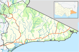
Marlo is a town in the Shire of East Gippsland, Victoria, Australia. It is located east near the mouth of the Snowy River where the Snowy River meets and flows into the Southern Ocean.[2][3][4] The name "Marlo" is generally accepted to have roots in tribal aboriginal language. "Marloo" meaning white clay is suggestive of the Marlo Bluff, whilst "Murloo" meaning "muddy banks" was reportedly used by the local indigenous people.[5] At the 2006 census, Marlo had a population of 564.[6]
- ^ Australian Bureau of Statistics (28 June 2022). "Marlo (Suburbs and Localities)". 2021 Census QuickStats. Retrieved 11 June 2023.
- ^ Department of Sustainability and Environment - Victoria (March 2006). "Forest Notes - Woods Point Camping Ground - Forest and Biodiversity – Orbost" (PDF). Department of Sustainability and Environment, State of Victoria - Australia. Retrieved 20 December 2009.
- ^ Department of Primary Industries, Victoria - Australia (1996–2009). "Victorian Resources Online Map Database - 8622 7 to 16". The State of Victoria. Retrieved 20 December 2009.
- ^ East Gippsland Shire Council (2007). "East Gippsland Map" (PDF). East Gippsland Shire Council, Victoria - Australia. Archived from the original (PDF) on 27 August 2010. Retrieved 20 December 2009.
- ^ Green, O.S. (1984), "Marlo - The Township, the Plains the Cape", Acacia Press, ISBN 978-0-85808-016-4
- ^ Australian Bureau of Statistics (27 June 2017). "Marlo (State Suburb)". 2016 Census QuickStats. Retrieved 29 January 2018.

