Back مرماريس Arabic مرماريس ARZ Marmaris AZ مارماریس AZB Мармарис BA Мармарыс BE Мармарыс BE-X-OLD Мармарис Bulgarian Мармарис CE Marmaris (kapital sa distrito) CEB
Marmaris | |
|---|---|
District and municipality | |
 Marmaris harbour | |
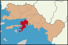
 Map showing Marmaris District in Muğla Province | |
| Coordinates: 36°51′N 28°16′E / 36.850°N 28.267°E | |
| Country | Turkey |
| Province | Muğla |
| Government | |
| • Mayor | Acar Ünlü (CHP) |
Area | 906 km2 (350 sq mi) |
| Elevation | 7 m (23 ft) |
| Population (2022)[1] | 97,818 |
| • Density | 110/km2 (280/sq mi) |
| Time zone | UTC+3 (TRT) |
| Postal code | 48700 |
| Area code | 0252 |
| Website | www |
Marmaris (Turkish pronunciation: [ˈmaɾmaɾis]) is a municipality and district of Muğla Province, Turkey.[2] Its area is 906 km2,[3] and its population is 97,818 (2022).[1] It is a port city and tourist resort on the Mediterranean coast, along the shoreline of the Turkish Riviera.
Although Marmaris is known for its honey, its main source of income is international tourism. It is located between two intersecting sets of mountains by the sea, though following a construction boom in the 1980s, little is left of the sleepy fishing village that Marmaris was until the late 20th century.
As an adjunct to the tourism industry, Marmaris is also a centre for sailing and diving, possessing two major and several smaller marinas. It is a popular wintering location for hundreds of cruising boaters.
Dalaman Airport is an hour's drive to the east.
Ferries operate from Marmaris to Rhodes and Symi in Greece.[4]
- ^ a b "Address-based population registration system (ADNKS) results dated 31 December 2022, Favorite Reports" (XLS). TÜİK. Retrieved 19 September 2023.
- ^ Büyükşehir İlçe Belediyesi, Turkey Civil Administration Departments Inventory. Retrieved 19 September 2023.
- ^ "İl ve İlçe Yüz ölçümleri". General Directorate of Mapping. Retrieved 19 September 2023.
- ^ "Sea Dreams - Ferry Booking, timetables and tickets". www.directferries.co.uk. Retrieved 2022-11-09.

