Back Mochudi AF موتشودى ARZ موچودی، بوتسوانا AZB Mochudi (kapital sa distrito sa Botswana) CEB Mochudi German Μοτσούντι Greek Mochudi Spanish Mochudi EU موچودی، بوتسوانا FA Mochudi Finnish
Mochudi | |
|---|---|
Village | |
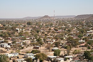
 View of Mochudi from a church bell tower | |
 | |
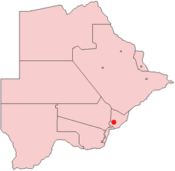
| Coordinates: 24°25′S 26°09′E / 24.417°S 26.150°E | |
| Country | Botswana |
| District | Kgatleng District |
| Settled | 1871 |
| Elevation | 938 m (3,077 ft) |
| Population (2022)[1] | |
• Total | 50,321 |
| Time zone | GMT +2 |
| Climate | BSh |
Mochudi is one of the larger villages in Botswana with a population of 50,321 people in 2022.[2] It is situated in the Bakgatla tribal region, in Kgatleng District, about 37 km (23 mi) northeast of Gaborone. The village lies several kilometres from the main Gaborone–Francistown road, and can be accessed through a short turn at Pilane.[3] Mochudi was settled by the Tswana people in 1871. The main attraction in Mochudi is the Phuthadikobo Museum which is perched at the top of a hill and holds a rich history of Bakgatla tribe and Batswana in general.
- ^ "2011 census". Archived from the original on January 11, 2013.
- ^ "Botswana: Districts, Cities, Towns, Urban Villages & Agglomerations - Population Statistics, Maps, Charts, Weather and Web Information". www.citypopulation.de. Retrieved 2024-10-04.
- ^ Latitude.to. "GPS coordinates of Mochudi, Botswana. Latitude: -24.4167 Longitude: 26.1500". Latitude.to, maps, geolocated articles, latitude longitude coordinate conversion. Retrieved 2020-05-29.
