Back Molkwerum CEB مولکوروم FA Molkwerum French Molkwar FY Molkwerum Dutch Molkwerum Polish Молкверюм Russian Молкверюм Ukrainian Molkwerum ZH-MIN-NAN
Molkwerum
Molkwar | |
|---|---|
Village | |
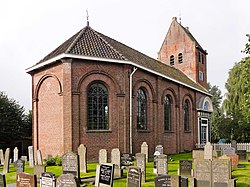
 St Lebuinus Church | |
 Location in the former Nijefurd municipality | |
| Coordinates: 52°54′1″N 5°23′53″E / 52.90028°N 5.39806°E | |
| Country | |
| Province | |
| Municipality | |
| Area | |
• Total | 10.72 km2 (4.14 sq mi) |
| Elevation | −0.1 m (−0.3 ft) |
| Population (2021)[1] | |
• Total | 360 |
| • Density | 34/km2 (87/sq mi) |
| Postal code | 8722[1] |
| Dialing code | 0514 |
Molkwerum (West Frisian: Molkwar [ˈmɔlkʋar]) is a village in Súdwest-Fryslân municipality in the province of Friesland, the Netherlands. It had a population of around 390 in January 2017.[3] Molkwerum used to be called Friese Doolhof (Frisian Maze), because it is built on numerous little islands dissected by canals in a random fashion.[4][5] The village used to contain 27 bridges.[6]
- ^ a b c "Kerncijfers wijken en buurten 2021". Central Bureau of Statistics. Retrieved 6 April 2022.
two entries
- ^ "Postcodetool for 8722HA". Actueel Hoogtebestand Nederland (in Dutch). Het Waterschapshuis. Retrieved 6 April 2022.
- ^ Kerncijfers wijken en buurten 2017 - CBS Statline
- ^ Cite error: The named reference
etymwas invoked but never defined (see the help page). - ^ Cite error: The named reference
wonderwas invoked but never defined (see the help page). - ^ "Molkwerum". Plaatsengids (in Dutch). Retrieved 6 April 2022.


