Back جبل مارافي Arabic جبل ماراپى ARZ Марапі BE Gunung Marapi BEW Marapi Catalan Gunung Marapi CEB Marapi Czech Marapi German Όρος Μαράπι Greek Monte Marapi Spanish
| Marapi | |
|---|---|
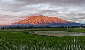
 Marapi in 2017 | |
| Highest point | |
| Elevation | 2,891 m (9,485 ft)[1] |
| Prominence | 2,116 m (6,942 ft) |
| Listing | Ultra Ribu |
| Coordinates | 00°22′48″S 100°28′27″E / 0.38000°S 100.47417°E[1] |
| Geography | |
West Sumatra, Indonesia | |
| Parent range | Barisan Mountains |
| Geology | |
| Mountain type | Complex volcano |
| Last eruption | 04 January 2025 |

The Marapi (Jawi: ماراڤي), or Mount Marapi (Indonesian: Gunung Marapi, Minangkabau: Gunuang Marapi, Jawi: ڬونوواڠ ماراڤي), is a complex volcano in West Sumatra, Indonesia, and is the most active volcano in Sumatra. Like that of its quasi-homonym on Java, its name means "Mountain of Fire". Its elevation is 2,885 metres (9,465.2 ft). Several cities and towns are situated around the mountain including Bukittinggi, Padang Panjang, and Batusangkar. The volcano is also popular among hikers.[2]
- ^ a b "Marapi". Global Volcanism Program. Smithsonian Institution. Retrieved 2023-12-04.
- ^ "Mount Marapi: Indonesia volcano death toll rises to 22". 2023-12-05. Archived from the original on 2023-12-05. Retrieved 2023-12-06.
