Back مايستيك (كونيتيكت) Arabic ميستيك ARZ میستیک، کنتیکت AZB Mystic (Connecticut) Catalan Мистик (Коннектикут) CE Mystic (lungsod sa Tinipong Bansa, Connecticut) CEB Mystic, Connecticut CY Mystic (Connecticut) Spanish Mystic (Connecticut) EU میستیک، کنتیکت FA
Mystic, Connecticut | |
|---|---|
| Village of Mystic | |
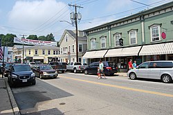
 Main Street, downtown Mystic | |
| Coordinates: 41°21′15″N 71°57′59″W / 41.35417°N 71.96639°W | |
| Country | |
| U.S. state | |
| County | New London |
| Region | Southeastern CT |
| Towns | Groton, Stonington |
| Area | |
• Total | 4.082 sq mi (10.57 km2) |
| • Land | 3.649 sq mi (9.45 km2) |
| • Water | 0.433 sq mi (1.12 km2) |
| Elevation | 10 ft (3 m) |
| Population (2020)[2] | |
• Total | 4,348 |
| • Density | 1,192/sq mi (460/km2) |
| Time zone | UTC−5 (Eastern (EST)) |
| • Summer (DST) | UTC−4 (EDT) |
| ZIP Codes | 06355, 06372, 06388 |
| Area code | 860 |
| FIPS code | 09-49810 |
| GNIS feature ID | 209165[3] |
| Website | mystic |
Mystic is a village and census-designated place (CDP) in Groton and Stonington, Connecticut, United States.
Mystic was a significant Connecticut seaport with more than 600 ships built over 135 years starting in 1784.[4] Mystic Seaport, located in the village, is the largest maritime museum in the United States and has preserved a number of sailing ships, such as the whaling ship Charles W. Morgan.[5][6] The village is located on the Mystic River which flows into Fishers Island Sound.[7] The Mystic River Bascule Bridge crosses the river in the center of the village.[8] The name "Mystic" is derived from the Pequot term "missi-tuk" describing a large river whose waters are driven into waves by tides or wind.[9] The population was 4,348 at the 2020 census.[2]
- ^ Cite error: The named reference
2020 Gazetteerwas invoked but never defined (see the help page). - ^ a b "Census - Geography Profile: Mystic CDP, Windham County, Connecticut". Retrieved August 7, 2023.
- ^ U.S. Geological Survey Geographic Names Information System: Mystic
- ^ "Crew of the Whaling Schooner Margaret 1907". Connecticuthistory.org. February 21, 2014. Retrieved April 15, 2020.
- ^ "About Mystic Seaport Museum".
- ^ "Charles W. Morgan". Mystic Seaport Museum. Retrieved April 15, 2020.
- ^ "Fishers Island Sound NOAA Chart 13214" (PDF). National Oceanic and Atmospheric Administration. Retrieved April 15, 2020.
- ^ "Mystic River Bridge, Spanning Mystic River at U.S. Route 1, Groton, New London County, CT". Library of Congress. Retrieved April 16, 2020.
- ^ "History of Mystic". Mystic River Historical Society. Retrieved April 16, 2020.


