Back نامبا (أيداهو) Arabic نامبا ARZ نامپا، آیداهو AZB Нампа Bulgarian Nampa (Idaho) BR Нампа CE Nampa (lungsod sa Tinipong Bansa) CEB نامپا، ئایداھۆ CKB Nampa Czech Nampa, Idaho CY
Nampa | |
|---|---|
 The former Nampa Department Store in Downtown Nampa | |
| Nickname: The Heart of the Treasure Valley | |
| Motto: What a Place to Live | |
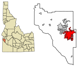
 Location of Nampa in Canyon County, Idaho | |
| Coordinates: 43°36′05″N 116°31′40″W / 43.60139°N 116.52778°W | |
| Country | United States |
| State | Idaho |
| County | Canyon |
| Founded | September 8, 1886 |
| Incorporated | April 17, 1891 |
| Area | |
• City | 34.77 sq mi (90.06 km2) |
| • Land | 33.48 sq mi (86.72 km2) |
| • Water | 0.15 sq mi (0.39 km2) |
| Elevation | 2,474 ft (754 m) |
| Population | |
• City | 100,200 |
• Estimate (2022)[4] | 110,951 |
| • Rank | US: 279th ID: 3rd |
| • Density | 2,992.7/sq mi (1,155.5/km2) |
| • Urban | 177,561 (US: 203rd) |
| • Metro | 811,336 (US: 75th) |
| • Combined | 899,574 (US: 67th) |
| Demonym | Nampon |
| Time zone | UTC–7 (Mountain (MST)) |
| • Summer (DST) | UTC–6 (MDT) |
| ZIP Codes | 83651, 83653, 83686, 83687 |
| Area code(s) | 208 and 986 |
| FIPS code | 16-56260 |
| GNIS feature ID | 2411208[2] |
| Website | www |
Nampa (/ˈnæmpə/ ⓘ) is the most populous city in Canyon County, Idaho, United States. The population was 100,200 at the 2020 census.[3] It is Idaho's third-most populous city. Nampa is about 20 miles (32 km) west of Boise along Interstate 84, and 6 miles (9.7 km) west of Meridian. It is the second principal city of the Boise metropolitan area. The name "Nampa" may have come from a Shoshoni word meaning 'moccasin' or 'footprint'.[5] According to toponymist William O. Bright, the name comes from the Shoshoni word /nampai/, meaning "foot".[6]
- ^ "2020 U.S. Gazetteer Files". United States Census Bureau. Retrieved July 24, 2022.
- ^ a b U.S. Geological Survey Geographic Names Information System: Nampa, Idaho
- ^ a b "Explore Census Data". United States Census Bureau. Retrieved January 16, 2024.
- ^ Cite error: The named reference
USCensusEst2022was invoked but never defined (see the help page). - ^ The Origin of the Name Nampa, Idaho State Historical Society, May 1965
- ^ Bright, William (2004). Native American Placenames of the United States. University of Oklahoma Press. p. 311. ISBN 9780806135984. Retrieved February 22, 2023.