Back نامور (كيبك) Arabic Namur (munisipyo) CEB Namur (Quebec) EU نامور، کبک FA Namur (Québec) French Namur (Québec) Italian Namur, Québec Swedish
Namur | |
|---|---|
 Lake in Namur | |
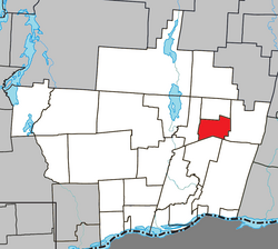
 Location within Papineau RCM | |
| Coordinates: 45°54′N 74°56′W / 45.900°N 74.933°W[1] | |
| Country | Canada |
| Province | Quebec |
| Region | Outaouais |
| RCM | Papineau |
| Settled | 1865 |
| Constituted | January 1, 1964 |
| Government | |
| • Mayor | Gilbert Dardel |
| • Federal riding | Argenteuil—Papineau—Mirabel |
| • Prov. riding | Papineau |
| Area | |
• Total | 58.10 km2 (22.43 sq mi) |
| • Land | 56.17 km2 (21.69 sq mi) |
| Population (2021)[3] | |
• Total | 633 |
| • Density | 11.3/km2 (29/sq mi) |
| • Pop 2016-2021 | |
| • Dwellings | 381 |
| Time zone | UTC−5 (EST) |
| • Summer (DST) | UTC−4 (EDT) |
| Postal code(s) | |
| Area code | 819 |
| Highways | |
| Website | www |

Namur (French pronunciation: [namyʁ] ⓘ) is a town and municipality in the Outaouais region of Quebec, Canada, part of the Papineau Regional County Municipality. It is nicknamed "la Nouvelle Belgique" (New Belgium).[4]
The vast majority of the local population lives off the timber industry, which is marked by the Loggers Summer Festival. Furthermore, the area's excellent fishing and hunting opportunities attract many tourists annually.[4]
- ^ Cite error: The named reference
toponymiewas invoked but never defined (see the help page). - ^ a b Cite error: The named reference
mamrotwas invoked but never defined (see the help page). - ^ a b Cite error: The named reference
cp21was invoked but never defined (see the help page). - ^ a b "Namur (Municipalité)" (in French). Commission de toponymie du Québec. Archived from the original on 2016-03-03. Retrieved 2009-01-12.
