Back Nantahala National Forest CEB Nantahala National Forest Danish Forêt nationale de Nantahala French 楠塔哈拉国家森林 Chinese
| Nantahala National Forest | |
|---|---|
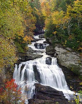
 Cullasaja Falls, Nantahala National Forest, in Macon County, North Carolina | |
| Location | North Carolina, United States |
| Nearest city | Franklin, NC |
| Coordinates | 35°14′02″N 83°33′33″W / 35.233842°N 83.559265°W |
| Area | 531,270 acres (2,150.0 km2)[1] |
| Established | February 6, 1907[2] |
| Governing body | U.S. Forest Service |
| Website | Nantahala National Forest |
The Nantahala National Forest (/ˌnæntəˈheɪlə/) is the largest of the four national forests in North Carolina, lying in the mountains and valleys of western North Carolina. The Nantahala is the second wettest region in the country, after the Pacific Northwest. Due to its environmental importance and historical ties with the Cherokee, the forest was officially established on January 29, 1920, by President Woodrow Wilson.[3][4] The word "Nantahala" is a Cherokee derived word, meaning "Land of the Noonday Sun." In some spots, the sun reaches the floors of the deep gorges of the forest only when it is high overhead at midday. This was part of the homeland of the historic Cherokee and their indigenous ancestors, who have occupied the region for thousands of years. The Nantahala River runs through it.
- ^ "Land Areas of the National Forest System" (PDF). U.S. Forest Service. January 2012. Retrieved June 28, 2012.
- ^ "The National Forests of the United States" (PDF). ForestHistory.org. Archived from the original (PDF) on July 16, 2011. Retrieved July 28, 2012.
- ^ Spencer, Marci (2017). Nantahala National Forest. Arcadia. ISBN 978-1-4396-6219-9. OCLC 1132371691.
- ^ "Nantahala National Forest, Conservation Landmark | NC DNCR". www.ncdcr.gov. 29 January 2016. Retrieved 2021-04-17.
