Back مقاطعة ناكيتوش Arabic Natchitoches Parish, Louisiana BAR নাচিটোচেস পারিশ, লুইসিয়ানা BPY Parròquia de Natchitoches Catalan Natchitoches Gông (Louisiana) CDO Накитош (кӀошт, Луизиана) CE Natchitoches Parish CEB Natchitoches Parish, Louisiana CY Natchitoches Parish German Parroquia de Natchitoches Spanish
Natchitoches Parish, Louisiana | |
|---|---|
| Parish of Natchitoches Paroisse des Natchitoches (French) | |
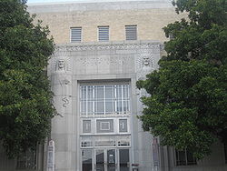
 Natchitoches Parish Courthouse (completed 1939 as a WPA project) | |
 Location within the U.S. state of Louisiana | |
 Louisiana's location within the U.S. | |
| Country | |
| State | |
| Region | Central Louisiana |
| Founded | April 10, 1805 |
| Named for | Natchitoches people |
| Parish seat | Natchitoches |
| Largest municipality | Ashland (area) Natchitoches (population) Campti (population density) |
| Incorporated municipalities | 9 (total)
|
| Area | |
• Total | 3,360 km2 (1,299 sq mi) |
| • Land | 3,240 km2 (1,252 sq mi) |
| • Water | 120 km2 (47 sq mi) |
| • percentage | 9 km2 (3.6 sq mi) |
| Population (2020) | |
• Total | 37,515 |
| • Rank | LA: 30th |
| • Density | 11/km2 (29/sq mi) |
| Time zone | UTC-6 (CST) |
| • Summer (DST) | UTC-5 (CDT) |
| Area code | 318 |
| Congressional district | 4th |
| Website | Natchitoches Parish Government |


Natchitoches Parish (French: Paroisse des Natchitoches or Les Natchitoches) is a parish located in the U.S. state of Louisiana. As of the 2020 census, the population was 37,515.[1] The parish seat and most populous municipality is Natchitoches, the largest by land area is Ashland, and the most densely populated area is Campti.[2] The parish was formed in 1805.[3]
The Natchitoches, LA Micropolitan Statistical Area includes all of Natchitoches Parish. This is the heart of the Cane River Louisiana Creole community, free people of color of mixed-race descent who settled here in the antebellum period. Their descendants continue to be Catholic and many are still French-speaking. The Cane River National Heritage Area includes the parish. Among the numerous significant historic sites in the parish is the St. Augustine Parish (Isle Brevelle) Church, a destination on the Louisiana African American Heritage Trail, founded in 2008.
Including extensive outbuildings at Magnolia and Oakland plantations, the Cane River Creole National Historical Park interprets the history and culture of the Louisiana Creoles. It is also on the Heritage Trail.
- ^ "Census - Geography Profile: Natchitoches Parish, Louisiana". United States Census Bureau. Retrieved January 22, 2023.
- ^ "Find a County". National Association of Counties. Retrieved June 7, 2011.
- ^ "Natchitoches Parish". Center for Regional Heritage Research. Retrieved September 6, 2014.

