Back مقاطعة نافارو (تكساس) Arabic مقاطعة نافارو، تكساس ARZ Navarro County, Texas BAR Навара (акруга) BE Наваро (окръг, Тексас) Bulgarian নাভারো কাউন্টি, টেক্সাস BPY Navarro Gông (Texas) CDO Navarro County CEB Navarro County Czech Navarro County, Texas CY
Navarro County | |
|---|---|
 The Navarro County Courthouse in Corsicana | |
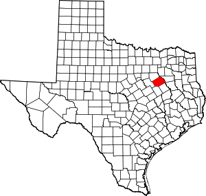
 Location within the U.S. state of Texas | |
 Texas's location within the U.S. | |
| Coordinates: 32°03′N 96°28′W / 32.05°N 96.47°W | |
| Country | |
| State | |
| Founded | April 25, 1846 |
| Named for | José Antonio Navarro |
| Seat | Corsicana |
| Largest city | Corsicana |
| Area | |
• Total | 1,086 sq mi (2,810 km2) |
| • Land | 1,010 sq mi (2,600 km2) |
| • Water | 76 sq mi (200 km2) 7.0% |
| Population (2020) | |
• Total | 52,624 |
| • Density | 48/sq mi (19/km2) |
| Time zone | UTC−6 (Central) |
| • Summer (DST) | UTC−5 (CDT) |
| Congressional district | 6th |
| Website | www |

Navarro County (/nəˈværoʊ/ nə-VARR-oh)[1] is a county in the U.S. state of Texas. As of the 2020 census, the population was 52,624.[2] Its county seat is Corsicana.[3] The county is named for José Antonio Navarro, a Tejano leader in the Texas Revolution who signed the Texas Declaration of Independence.
Navarro County comprises the Corsicana micropolitan statistical area, which is also part of the Dallas-Fort Worth, TX combined statistical area.
- ^ "Texas Almanac Pronunciation Guide" (PDF). Texas State Historical Association. Archived (PDF) from the original on October 9, 2022. Retrieved January 22, 2020.
- ^ "Navarro County, Texas". United States Census Bureau. Retrieved February 23, 2021.
- ^ "Find a County". National Association of Counties. Retrieved June 7, 2011.