Back Noord-Pohjanmaa AF بوهيانما الشمالية Arabic Ostrobotnia del Norte AST SuomiaPohjoisPohjanmaaGola AVK Şimali Ostrobotniya AZ Ostrobothnia Kalér BAN Sjeverna Ostrobotnija BS Ostrobòtnia del Nord Catalan Къилбаседа Остроботни CE Pohjois-Pohjanmaa CEB
This article needs additional citations for verification. (February 2019) |
You can help expand this article with text translated from the corresponding article in Finnish. (June 2023) Click [show] for important translation instructions.
|
North Ostrobothnia
| |
|---|---|
| Region of North Ostrobothnia Pohjois-Pohjanmaan maakunta Landskapet Norra Österbotten | |
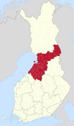
 North Ostrobothnia on a map of Finland | |
| Coordinates: 65°N 026°E / 65°N 26°E | |
| Country | Finland |
| Historical province | Ostrobothnia |
| Capital | Oulu |
| Other towns | Haapajärvi, Haapavesi, Kalajoki, Kuusamo, Nivala, Oulainen, Pudasjärvi, Pyhäjärvi, Raahe and Ylivieska |
| Area | |
• Total | 37,149.23 km2 (14,343.40 sq mi) |
| Population (2023) | |
• Total | 418,212 |
| • Density | 11/km2 (29/sq mi) |
| GDP | |
| • Total | €12.502 billion (2015) |
| • Per capita | €30,779 (2015) |
| Time zone | UTC+2 (EET) |
| • Summer (DST) | UTC+3 (EEST) |
| ISO 3166 code | FI-14 |
| NUTS | 1A2 |
| Regional song | Kymmenen Virran Maa (The Land of Ten Mighty Streams) |
| Regional animal | Stoat (Mustela erminea) |
| Regional bird | Common crane (Grus grus) |
| Regional fish | Common whitefish (Coregonus lavaretus) |
| Regional flower | Marsh Labrador tea (Rhododendron tomentosum) |
| Regional rock | Schist |
| Regional lake | Lake Pyhäjärvi |
| Website | www |
North Ostrobothnia[2] (Finnish: Pohjois-Pohjanmaa; Swedish: Norra Österbotten) is a region of Finland. It borders the Finnish regions of Lapland, Kainuu, North Savo, Central Finland and Central Ostrobothnia, as well as the Russian Republic of Karelia. The easternmost corner of the region between Lapland, Kainuu and the Russian border is known as Koillismaa ("North-East Finland").[3]
- ^ Regions and Cities > Regional Statistics > Regional Economy > Regional GDP per Capita, OECD.Stats. Accessed on 16 November 2018.
- ^ "Tilastokeskus – Luokitukset – Regions". stat.fi.
- ^ Jyrki Muona & Juha Viramo (1986). The coleoptera of the Koillismaa area (Ks.), North-East Finland. Oulu: University of Oulu. ISBN 951-42-2163-X.
