Back أواتونا Arabic اواتونا ARZ اوواتانا، مینهسوتا AZB Owatonna Catalan Оватонна (Миннесота) CE Owatonna (kapital sa kondado) CEB Owatonna Danish Owatonna DAG Owatonna German Owatonna (Minnesota) Spanish
Owatonna | |
|---|---|
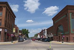
 Downtown Owatonna | |
| Nickname: O-Town | |
 | |
| Coordinates: 44°05′28″N 93°13′52″W / 44.09111°N 93.23111°W | |
| Country | United States |
| State | Minnesota |
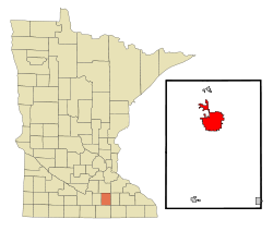
| County | Steele |
| Settled | 1854 |
| Platted | September 1855 |
| Incorporated (town) | August 9, 1858 |
| Incorporated (city) | February 23, 1865 |
| Named for | Straight River |
| Government | |
| • Type | Representative council |
| • Mayor | Matt Jessop |
| Area | |
• Total | 15.20 sq mi (39.36 km2) |
| • Land | 15.11 sq mi (39.14 km2) |
| • Water | 0.09 sq mi (0.22 km2) |
| Elevation | 1,132 ft (345 m) |
| Population | |
• Total | 26,420 |
• Estimate (2022)[4] | 26,470 |
| • Density | 1,748.16/sq mi (674.98/km2) |
| Time zone | UTC-6 (Central) |
| • Summer (DST) | UTC-5 (CDT) |
| ZIP code | 55060 |
| Area code | 507 |
| FIPS code | 27-49300 |
| GNIS feature ID | 2396114[2] |
| Website | owatonna.gov |
Owatonna (/ˌoʊwəˈtɒnə/ OH-wə-TON-ə)[5] is a city and the county seat of Steele County, Minnesota, United States. The population was 26,420 at the 2020 census.[3] Owatonna is home to the Steele County Fairgrounds, which hosts the Steele County Free Fair in August.
Interstate 35 and U.S. Highways 14 and 218 are three of the main routes in the city.
- ^ "2020 U.S. Gazetteer Files". United States Census Bureau. Retrieved July 24, 2022.
- ^ a b U.S. Geological Survey Geographic Names Information System: Owatonna, Minnesota
- ^ a b "Explore Census Data". United States Census Bureau. Retrieved May 1, 2023.
- ^ Cite error: The named reference
USCensusEst2022was invoked but never defined (see the help page). - ^ "Minnesota Pronunciation Guide". Associated Press. Archived from the original on July 22, 2011. Retrieved July 4, 2011.