Back اوکستد AZB Oxted (lungsod) CEB Oxted CY Oxted German Oxted Spanish Oxted EU اوکستد FA Oxted French Oxted GA Oxted Italian
| Oxted | |
|---|---|
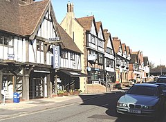
 The timber-framed stucco façades of buildings in Oxted | |
Location within Surrey | |
| Area | 15.15 km2 (5.85 sq mi) |
| Population | 11,314 (civil parish as of 2011)[1] 13,452 (built-up area)[2] |
| • Density | 747/km2 (1,930/sq mi) |
| OS grid reference | TQ3953 |
| • London | 17.9 mi (28.8 km) |
| Civil parish |
|
| District | |
| Shire county | |
| Region | |
| Country | England |
| Sovereign state | United Kingdom |
| Post town | Oxted |
| Postcode district | RH8 |
| Dialling code | 01883 |
| Police | Surrey |
| Fire | Surrey |
| Ambulance | South East Coast |
| UK Parliament | |
Oxted is a town and civil parish in the Tandridge district of Surrey, England, at the foot of the North Downs, 9 miles (14 km) south-east of Croydon, 9 miles (14 km) west of Sevenoaks, and 9 miles (14 km) north of East Grinstead.
Oxted is a commuter town and Oxted railway station has direct train services to London. Its main developed area is contiguous with the village of Limpsfield. The headwaters of the River Eden unite in the town, east of Titsey Place. The Eden feeds into Kent's longest river, the Medway. Only the southern slope of the North Downs is steep and its towns and farmland form the Vale of Holmesdale, a series of headwaters across Surrey and Kent to separate rivers.
The settlements of Hurst Green and Holland within the civil parish to the south are continuous, but almost wholly residential, areas.
- ^ Key Statistics; Quick Statistics: Population Density Archived 11 February 2003 at the Wayback Machine United Kingdom Census 2011 Office for National Statistics Retrieved 21 November 2013
- ^ "Custom report - Nomis - Official Labour Market Statistics". Archived from the original on 1 December 2021. Retrieved 4 February 2019.
