Back ضاحية بلكاد Arabic بلكاد ARZ पलक्कड़ जिला BH পালঘাট জেলা Bengali/Bangla Palakkad district CEB Palakkad (Distrikt) German Distrito de Palakkad Spanish Palakkad barrutia EU بخش پالاکاد FA Palakkad (district) French
Palakkad | |
|---|---|
|
Clockwise from top: Palakkad Fort, Ottapalam town, Alathur town, Malampuzha Dam Water Canal, Pattambi town, Palakkad city | |
| Nickname: The Granary of Kerala | |
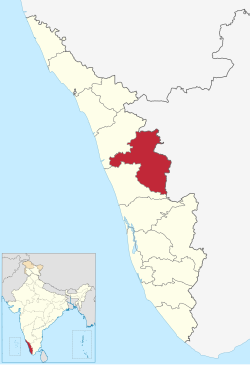
 Location in Kerala | |
| Coordinates: 10°46′30″N 76°39′04″E / 10.775°N 76.651°E | |
| Country | |
| State | Kerala |
| Region | South Malabar |
| Headquarters | Palakkad |
| Government | |
| • Collector | Dr.S.Chitra IAS[1] |
| • S.P | R. Anand, IPS |
| • DFO | Narendranath Veluri, IFS |
| Area | |
• Total | 4,482 km2 (1,731 sq mi) |
| • Rank | 2nd |
| Highest elevation | 2,383 m (7,818 ft) |
| Population (2018)[2] | |
• Total | 2,952,254 |
| • Rank | 5 |
| • Density | 659/km2 (1,710/sq mi) |
| Languages | |
| • Official | Malayalam, English[3] |
| • Regional | |
| Religions | |
| • Religion (2011) | |
| Time zone | UTC+5:30 (IST) |
| ISO 3166 code | IN-KL-PKD |
| Vehicle registration | KL-09 Palakkad, KL-49 Alathur, KL-50 Mannarkkad, KL-51 Ottappalam, KL-52 Pattambi, KL-70 Chittur-Thathamangalam |
| HDI (2005) | |
| Literacy | 89.31%[7] |
| Website | www |
Palakkad (Malayalam: [pɐːlɐkːɐːɖɨ̆] ) is one of the 14 districts in the Indian state of Kerala. It was carved out of the southeastern region of the former Malabar District on 1 January 1957. It is located at the central region of Kerala and is the second largest district in the state after Idukki. The city of Palakkad is the district headquarters. Palakkad is bordered on the northwest by the Malappuram district, on the southwest by the Thrissur district, on the northeast by Nilgiris district, and on the east by Coimbatore district of Tamil Nadu. The district is nicknamed "The granary of Kerala". Palakkad is the gateway to Kerala due to the presence of the Palakkad Gap, in the Western Ghats. The 2,383 m high Anginda peak, which is situated in the border of Palakkad district, Nilgiris district, and Malappuram district, in Silent Valley National Park, is the highest point of elevation in Palakkad district. Palakkad city is about 347 kilometres (216 mi) northeast of the state capital, Thiruvananthapuram.
The total area of the district is 4,480 km2 (1,730 sq mi) which is 11.5% of the state's area which makes it the second largest district of Kerala. Out of the total area of 4,480 km2 (1,730 sq mi), about 1,360 km2 (530 sq mi) of land is covered by forests. Most parts of the district fall in the midland region (elevation 75–250 m or 246–820 ft), except the Nelliampathy-Parambikulam area in the Chittur taluk in the south and Attappadi-Malampuzha area in the north, which are hilly and fall in the highland region (elevation > 250 m or 820 ft). Attappadi valley of Palakkad district, along with the Chaliyar valley of the neighbouring Nilambur region (Eastern Eranad region) in Malappuram district, is known for natural Gold fields,[8] which is also seen in other parts of Nilgiri Biosphere Reserve.
The climate is pleasant for most parts of the year, the exception is the summer months. There is sufficient rainfall and it receives more rainfall than the extreme southern districts of Kerala. The district has many small and medium rivers, which are tributaries of the Bharathapuzha River. A number of dams have been built across these rivers, the largest being the Malampuzha dam. The largest in volume capacity is the Parambikulam Dam[9] Bhavani River, which is a tributary of Kaveri River, also flows through the district. Kadalundi River has its origin in Silent Valley National Park. The Chalakudy River also flows through district.
Palakkad district have total number of seven municipalities.The largest city in the district is the Palakkad municipality.[10] The municipalities in the district are Palakkad city, Ottapalam, Shornur, Chittur-Tattamangalam, Pattambi, Cherpulassery and Mannarkkad.[11] Out of the total Palakkad District population for 2011 Census of India, 24.09 percent lives in urban regions of district. In total 676,810 people lives in urban areas of which males are 328,012 and females are 348,798. Sex Ratio in urban region of Palakkad District is 1063 as per 2011 Census of India data. Similarly child sex ratio in Palakkad District was 959 in 2011 census. Child population (0–6) in urban region was 70,405 of which males and females were 35,933 and 34,472. This child population figure of Palakkad district is 10.95% of total urban population.
- ^ "About District". Palakkad District. Retrieved 6 December 2021.
- ^ Annual Vital Statistics Report – 2018 (PDF). Thiruvananthapuram: Department of Economics and Statistics, Government of Kerala. 2020. p. 55.
- ^ "The Kerala Official Language (Legislation) Act, 1969" (PDF). Archived from the original on 11 September 2014.
{{cite web}}: CS1 maint: unfit URL (link) - ^ Cite error: The named reference
languageswas invoked but never defined (see the help page). - ^ "Table C-01: Population by religious community: Kerala". Census of India. Registrar General and Census Commissioner of India. 2011.
- ^ "Kerala | UNDP in India". UNDP.
- ^ Cite error: The named reference
districtcensuswas invoked but never defined (see the help page). - ^ "Minerals Resources". dmg.kerala.gov.in.
- ^ "Fact sheet on Indian dams at Diehardindian.com". Archived from the original on 13 December 2006.
- ^ "*** Official WebSite Of Palakkad District ***". Palakkad.nic.in. Retrieved 18 October 2011.
- ^ "Muncipalities [sic] | Palakkad | India".


