Back بالوس فيرديس إستيتس Arabic بالوس فيرديس استاتيس ARZ Палос Вердес Естейтс (град, Калифорния) Bulgarian Palos Verdes Estates Catalan Палос-Вердес (Калифорни) CE Palos Verdes Estates CEB Palos Verdes Estates Czech Palos Verdes Estates German Palos Verdes Estates EO Palos Verdes Estates Spanish
Palos Verdes Estates, California | |
|---|---|
|
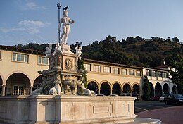
Clockwise: Malaga Cove Plaza; Plaza archway; Malaga Cove Library | |
 Location of Palos Verdes Estates in Los Angeles County, California | |
| Coordinates: 33°47′13″N 118°23′48″W / 33.78694°N 118.39667°W | |
| Country | |
| State | |
| County | Los Angeles |
| Incorporated | December 20, 1939[1] |
| Government | |
| • Type | Council–manager[2] |
| • Mayor | Victoria Lozzi |
| • Mayor Pro Tem | Michael Kemps |
| • City Council | Derek Lazzaro David McGowan Craig Quinn |
| Area | |
• Total | 4.77 sq mi (12.36 km2) |
| • Land | 4.77 sq mi (12.36 km2) |
| • Water | 0.00 sq mi (0.00 km2) 0.01% |
| Elevation | 210 ft (64 m) |
| Population | |
• Total | 13,347 |
| • Density | 2,800/sq mi (1,100/km2) |
| Time zone | UTC−08:00 (PST) |
| • Summer (DST) | UTC−07:00 (PDT) |
| ZIP Code | 90274[6] |
| Area codes | 310/424 |
| FIPS code | 06-55380 |
| GNIS feature IDs | 1652770, 2411363 |
| Website | www |
Palos Verdes Estates is a coastal city in Los Angeles County, California, United States, situated on the Palos Verdes Peninsula and neighboring Rancho Palos Verdes and Rolling Hills Estates. The city was master-planned by the noted American landscape architect and planner Frederick Law Olmsted Jr. The city is located along the Southern California coastline of the Pacific Ocean.
The population was 13,347 at the 2020 census, a slight decrease from its 2010 population of 13,438. Palos Verdes Estates is one of the wealthiest cities in the United States. The 90274 ZIP code (covering the cities of Palos Verdes Estates and Rolling Hills) is considered some of the most exclusive and expensive neighborhoods in the United States.[7][8] The city is also known for its high-performing school district, hiking trails, and oceanfront properties.[9][10][11]
- ^ "California Cities by Incorporation Date". California Association of Local Agency Formation Commissions. Archived from the original (Word) on November 3, 2014. Retrieved August 25, 2014.
- ^ "Roadmap to City Services". Palos Verdes Estates. Archived from the original on May 12, 2015. Retrieved January 30, 2015.
- ^ "2019 U.S. Gazetteer Files". United States Census Bureau. Archived from the original on August 26, 2022. Retrieved July 1, 2020.
- ^ "Palos Verdes Estates". Geographic Names Information System. United States Geological Survey, United States Department of the Interior. Retrieved October 13, 2014.
- ^ "Palos Verdes Estates (city) QuickFacts". United States Census Bureau. Retrieved April 28, 2022.
- ^ "USPS - ZIP Code Lookup - Find a ZIP+ 4 Code By City Results". Archived from the original on September 29, 2007. Retrieved January 18, 2007.
- ^ Woolsey, Matt. "In Pictures: Most Expensive ZIP Codes". Forbes. Archived from the original on August 12, 2017. Retrieved September 7, 2017.
- ^ "Richest Cities in California". PropertyClub. Archived from the original on December 8, 2023. Retrieved October 24, 2023.
- ^ "Untitled1". February 6, 2004. Archived from the original on February 6, 2004. Retrieved July 20, 2017.
- ^ Beast, The Daily (August 27, 2014). "America's Top High Schools 2014". The Daily Beast. Retrieved July 20, 2017.
- ^ Fry, Hannah; Shalby, Colleen; Cosgrove, Jaclyn (May 15, 2019). "Racist 'promposal' shows disconnect between affluent Palos Verdes Estates and the rest of L.A." Los Angeles Times. Retrieved May 16, 2019.


