Back نهر بالوس Arabic نهر پالوس ARZ Palouse River CEB Палус (юханшыв) CV Palouse River German Palouse (rivière) French Palouse (fiume) Italian Palouse River NB Палус (река) Russian Палус Ukrainian
| Palouse River | |
|---|---|
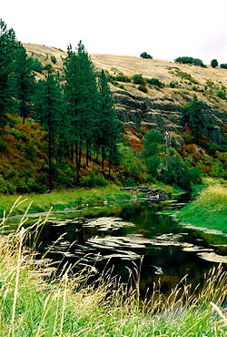
 Several miles downstream from its fork in Colfax; looking west in 2007 | |
| Location | |
| Country | United States |
| State | Washington, Idaho |
| County | Franklin, Whitman, Adams, Latah |
| Physical characteristics | |
| Source | Rocky Mountains |
| • coordinates | 46°58′07″N 116°27′31″W / 46.9685°N 116.4587°W[1] |
| Mouth | Snake River |
• coordinates | 46°35′24″N 118°12′55″W / 46.59000°N 118.21528°W[1] |
• elevation | 541 ft (165 m)[1] |
| Length | 167 mi (269 km) |
| Basin size | 3,303 sq mi (8,550 km2)[2] |
| Discharge | |
| • location | river mile 19.6 at Hooper[3][4] |
| • average | 599 cu ft/s (17.0 m3/s)[3][5] |
| • minimum | 0 cu ft/s (0 m3/s) |
| • maximum | 33,500 cu ft/s (950 m3/s) |
The Palouse River is a tributary of the Snake River in Washington and Idaho, in the northwest United States. It flows for 167 miles (269 km)[6] southwestwards, primarily through the Palouse region of southeastern Washington. It is part of the Columbia River Basin, as the Snake River is a tributary of the Columbia River.
Its canyon was carved out by a fork in the catastrophic Missoula Floods of the previous ice age, which spilled over the northern Columbia Plateau and flowed into the Snake River, eroding the river's present course in a few thousand years.
- ^ a b c "Palouse River". Geographic Names Information System. United States Geological Survey, United States Department of the Interior. 10 September 1979. Retrieved 2010-06-30.
- ^ Cite error: The named reference
nwcouncilwas invoked but never defined (see the help page). - ^ a b Cite error: The named reference
wdrwas invoked but never defined (see the help page). - ^ "USGS 13351000 Palouse River at Hooper, WA". USGS. Retrieved May 16, 2018.
- ^ "USGS 13351000 Palouse River at Hooper, WA". USGS. Retrieved May 16, 2018.
- ^ U.S. Geological Survey. National Hydrography Dataset high-resolution flowline data. The National Map, accessed May 3, 2011
