Back بارسونز (كانساس) Arabic بارسونز (لابيت, كانزاس) ARZ پارزونز، کانزاس AZB Parsons (Kansas) Catalan Парсонс (Канзас) CE Parsons (lungsod sa Tinipong Bansa, Kansas) CEB پارسۆنز CKB Parsons (Kansas) German Parsons (Kansas) Spanish Parsons (Kansas) EU
Parsons, Kansas | |
|---|---|
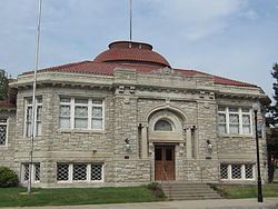
 Former Parsons Carnegie Library, now Parsons Carnegie Arts Center (2013) | |
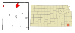
 Location within Labette County and Kansas | |
 | |
| Coordinates: 37°20′21″N 95°16′11″W / 37.33917°N 95.26972°W[1] | |
| Country | United States |
| State | Kansas |
| County | Labette |
| Founded | 1870 |
| Incorporated | 1871 |
| Named for | Levi Parsons |
| Government | |
| • Mayor | Kevin Cruse |
| Area | |
• Total | 10.72 sq mi (27.76 km2) |
| • Land | 10.63 sq mi (27.54 km2) |
| • Water | 0.09 sq mi (0.22 km2) |
| Elevation | 902 ft (275 m) |
| Population | |
• Total | 9,600 |
| • Density | 900/sq mi (350/km2) |
| Time zone | UTC-6 (CST) |
| • Summer (DST) | UTC-5 (CDT) |
| ZIP code | 67357 |
| Area code | 620 |
| FIPS code | 20-54675[1] |
| GNIS ID | 469782[1] |
| Website | parsonsks.com |
Parsons is a city in Labette County, Kansas, United States.[1] As of the 2020 census, the population of the city was 9,600.[3][4] It is the most populous city of Labette County, and the second-most populous city in the southeastern region of Kansas. It is home to Labette Community College and the Parsons State Hospital & Training Center.
- ^ a b c d e "Parsons, Kansas", Geographic Names Information System, United States Geological Survey, United States Department of the Interior
- ^ "2019 U.S. Gazetteer Files". United States Census Bureau. Retrieved July 24, 2020.
- ^ a b "Profile of Parsons, Kansas (CDP) in 2020". United States Census Bureau. Archived from the original on June 12, 2022. Retrieved June 12, 2022.
- ^ a b "QuickFacts; Parsons, Kansas; Population, Census, 2020 & 2010". United States Census Bureau. Archived from the original on August 26, 2021. Retrieved August 26, 2021.
