Back بنيتنجويشين (أونتاريو) Arabic بينيتانجويشين ARZ Penetanguishene ATJ Penetanguishene CEB Penetanguishene German پنتنگویشین FA Penetanguishene French Penetanguishene Italian Penetanguishene Polish Penetanguishene Portuguese
Penetanguishene | |
|---|---|
| Town of Penetanguishene Ville de Penetanguishene (French) | |
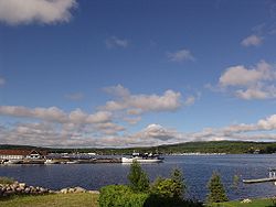
 Town docks on Penetanguishene Bay. | |
| Coordinates: 44°46′N 79°56′W / 44.767°N 79.933°W | |
| Country | Canada |
| Province | Ontario |
| County | Simcoe |
| Incorporated | February 22, 1882 |
| Government | |
| • Mayor | Douglas Rawson |
| • MPs | Adam Chambers |
| • MPPs | Jill Dunlop |
| Area | |
| • Land | 25.58 km2 (9.88 sq mi) |
| Population (2016)[2] | |
• Total | 8,962 |
| • Density | 350.3/km2 (907/sq mi) |
| Time zone | UTC-5 (Eastern (EST)) |
| • Summer (DST) | UTC-4 (EDT) |
| Forward sortation area | |
| Area code | 705 |
| Website | www |
Penetanguishene (/pɛnɪˈtæŋɡwɪʃiːn/ ⓘ, sometimes shortened to Penetang) is a town in Simcoe County, Ontario, Canada. It is located on the southeasterly tip of Georgian Bay. Incorporated on February 22, 1882, this bilingual (French and English) community has a population of 8,962 in the Canada 2016 Census.
The name Penetanguishene is believed to come from either the Wyandot[3] or Abenaki via Ojibwe,[4] meaning "land of the white rolling sands".
- ^ Cite error: The named reference
cp2011awas invoked but never defined (see the help page). - ^ "Census Profile, 2016 Census: Penetanguishene". Statistics Canada. 8 February 2017. Retrieved July 6, 2019.
- ^ "Education Day: Canadian Aboriginal Festival. November 25, 2005. Elementary Teachers' Federation of Ontario" (PDF). Retrieved 13 March 2023.[permanent dead link]
- ^ Osborne, A. C. "Old Penetanguishene: Sketches of its Pioneer, Naval and Military Days" in Pioneer Papers, No. 5. Simcoe County Pioneer and Historical Society (Barrie, ON: 1912).

