Back بونبي Arabic Панпеі BE Понпей Bulgarian Pohnpei Island CEB Pohnpei Czech Pohnpei German Ponape EO Pohnpei Spanish Pohnpei ET Pohnpei EU
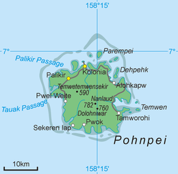
 Map of Pohnpei | |
| Geography | |
|---|---|
| Coordinates | 06°54′00″N 158°13′30″E / 6.90000°N 158.22500°E |
| Archipelago | Senyavin Islands |
| Adjacent to | Pacific Ocean |
| Area | 334 km2 (129 sq mi) |
| Highest elevation | 782 m (2566 ft) |
| Highest point | Mount Nanlaud |
| Administration | |
| State | Pohnpei |
| Largest settlement | Kolonia (pop. 6,074) |
| Demographics | |
| Population | 36,832 (2020) |

Pohnpei (formerly known as Ponape or Ascension, from Pohnpeian: "upon (pohn) a stone altar (pei)") is an island of the Senyavin Islands which are part of the larger Caroline Islands group. It belongs to Pohnpei State, one of the four states in the Federated States of Micronesia (FSM). Major population centers on Pohnpei include Palikir, the FSM's capital, and Kolonia, the capital of Pohnpei State. Pohnpei is the largest island in the FSM, with an area of 334 km2 (129 sq mi), and a highest point of 782 m (2,566 ft), the most populous with 36,832 people, and the most developed single island in the FSM.
Pohnpei is home to the megaliths and ruined city of Nan Madol, built of artificial islands off the island's eastern shore beginning in the 8th or 9th century. An important archaeological site, it was declared a national historic site in 1985.
Pohnpei contains a wealth of biodiversity. It is one of the wettest places on Earth with annual recorded rainfall exceeding 7,600 mm (300 in)[1] each year in certain mountainous locations. It is home to the ka tree (Terminalia carolinensis) found only in Pohnpei and Kosrae.[2]
- ^ "Rainfall Climatology for Pohnpei Islands, Federated States of". Archived from the original on 21 February 2022. Retrieved 3 March 2022.
- ^ Nature Conservancy Magazine February / March 2015 page 36