Back بونتوتوك Arabic بونتوتوك ARZ پانتوتوک، میسیسیپی AZB Pontotoc Catalan Понтоток (Миссисипи) CE Pontotoc CEB Pontotoc, Mississippi CY Pontotoc (Mississippi) German Pontotoc Spanish Pontotoc (Mississippi) EU
This article needs additional citations for verification. (May 2009) |
Pontotoc, Mississippi | |
|---|---|
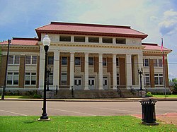
 Pontotoc County Courthouse in Pontotoc | |
 Location of Pontotoc, Mississippi | |
| Coordinates: 34°14′55″N 89°00′24″W / 34.24861°N 89.00667°W | |
| Country | United States |
| State | Mississippi |
| County | Pontotoc |
| Government | |
| • Mayor | Bob Peeples (D)[1][2] |
| Area | |
• Total | 11.33 sq mi (29.36 km2) |
| • Land | 11.18 sq mi (28.96 km2) |
| • Water | 0.15 sq mi (0.40 km2) |
| Elevation | 459 ft (140 m) |
| Population (2020) | |
• Total | 5,640 |
| • Density | 504.47/sq mi (194.78/km2) |
| Time zone | UTC-6 (Central (CST)) |
| • Summer (DST) | UTC-5 (CDT) |
| ZIP code | 38863 |
| Area code | 662 |
| FIPS code | 28-59160 |
| GNIS feature ID | 2404549[4] |
| Website | www |
Pontotoc is a city in and the county seat of Pontotoc County, Mississippi, located to the west of the larger city of Tupelo. The population was 5,640 at the 2020 census. Pontotoc is a Chickasaw word that means, “Land of the Hanging Grapes.” A section of the city largely along Main Street and Liberty Street has been designated the Pontotoc Historic District and is listed on the National Register of Historic Places.[5] The Treaty of Pontotoc Site is also listed on the National Register.[6] The Treaty of Pontotoc Creek, part of U.S. president Andrew Jackson's Indian Removal policy, ceded millions of acres of Native American lands and relocated the Chicakasaw west of the Mississippi River.
- ^ Helms, David (February 26, 2024). "Mayor Peeples outlines 2024 city projects". Northeast Mississippi Daily Journal. Retrieved November 29, 2024.
- ^ "Official Recapitulation" (PDF). Mississippi Secretary of State. Retrieved November 28, 2024.
- ^ "2020 U.S. Gazetteer Files". United States Census Bureau. Retrieved July 24, 2022.
- ^ a b U.S. Geological Survey Geographic Names Information System: Pontotoc, Mississippi
- ^ "National Register of Historic Places : Pontotoc Historic District" (PDF). Apps.mdah.ms.gov. Retrieved December 23, 2023.
- ^ "National Register of Historic Places : Treaty of Pontotoc Site" (PDF). Apps.mdah.ms.gov. Retrieved December 23, 2023.


