Back مقاطعة بانتوتوك (أوكلاهوما) Arabic Pontotoc County, Oklahoma BAR Понтоток (окръг, Оклахома) Bulgarian পোন্টোটোক কাউন্টি, ওকলাহোমা BPY Pontotoc Gông (Oklahoma) CDO Pontotoc County (kondado sa Tinipong Bansa, Oklahoma) CEB Pontotoc County, Oklahoma CY Pontotoc County (Oklahoma) German Condado de Pontotoc (Oklahoma) Spanish Pontotoci maakond ET
Pontotoc County | |
|---|---|
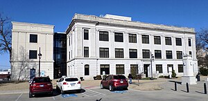
 Pontotoc County Courthouse in Ada | |
 Location within the U.S. state of Oklahoma | |
 Oklahoma's location within the U.S. | |
| Coordinates: 34°43′N 96°41′W / 34.72°N 96.69°W | |
| Country | |
| State | |
| Founded | 1907 |
| Named for | Chickasaw word for the region meaning either "cattail prairie" "land of hanging grapes" |
| Seat | Ada |
| Largest city | Ada |
| Area | |
• Total | 725 sq mi (1,880 km2) |
| • Land | 720 sq mi (1,900 km2) |
| • Water | 4.8 sq mi (12 km2) 0.7% |
| Population (2020) | |
• Total | 38,065 |
| • Density | 53/sq mi (20/km2) |
| Congressional district | 4th |
Pontotoc County is a county in the south central part of Oklahoma. As of the 2020 census, the population was 38,065.[1] Its county seat is Ada.[2] The county was created at statehood from part of the Chickasaw Nation in Indian Territory. It was named for a historic Chickasaw tribal area in Mississippi. According to the Encyclopedia of Oklahoma History and Culture, Pontotoc is usually translated "cattail prairie" or "land of hanging grapes."[3]
Pontotoc County comprises the Ada, OK micropolitan statistical area.
The Chickasaw Nation's headquarters are in Ada.
- ^ "Pontotoc County, Oklahoma". United States Census Bureau. Retrieved May 20, 2023.
- ^ "Find a County". National Association of Counties. Retrieved June 7, 2011.
- ^ Turner, Alvin O. "Pontotoc County," Encyclopedia of Oklahoma History and Culture, Oklahoma Historical Society, 2009. Accessed April 4, 2015.