Back Hafen Boston German Bostongo portua EU Port de Boston French Bostonska luka Croatian Bostonska luka SH Port of Boston Swedish 波士頓港 Chinese
| Port of Boston | |
|---|---|
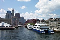
 Long Wharf in downtown Boston, once the main commercial wharf within the port, but now used by ferries and cruise boats. | |
 Click on the map for a fullscreen view | |
| Location | |
| Country | |
| Location | Boston, Suffolk County, MA |
| Coordinates | 42°21′48.96″N 71°2′11.77″W / 42.3636000°N 71.0366028°W[1] |
| Details | |
| Operated by | Massachusetts Port Authority (Massport) |
| Owned by | Government of Massachusetts |
| Type of harbour | Natural/artificial |
| Size of harbour | 500 acres (200 ha) |
| No. of berths |
|
| No. of wharfs |
|
| No. of piers |
|
| Employees |
|
| Port Director | Lauren Gleason |
| Draft depth | 40 feet |
| Air draft | Unrestricted |
| Statistics | |
| Website ]https://www.massport.com/ www.massport.com] | |
The Port of Boston (AMS Seaport Code: 0401,[2] UN/LOCODE: US BOS) is a major seaport located in Boston Harbor and adjacent to the City of Boston.[3] It is the largest port in Massachusetts and one of the principal ports on the East Coast of the United States.[1][4]
The Port of Boston was historically important for the growth of the City of Boston, and was originally located in what is now the downtown area of the city, called Long Wharf. Land reclamation and conversion to other uses means that the downtown area no longer handles commercial traffic, although there is still considerable ferry and leisure usage at Long Wharf. Today the principal cargo handling facilities are located in the Boston neighborhoods of Charlestown, East Boston, and South Boston, and in the neighboring city of Everett. The Port of Boston has also been an entry point for many immigrants.[5]
- ^ a b admin. (2010). "Port of Boston". Ports.com. Archived from the original on 2010-11-25. Retrieved June 23, 2011.
- ^ Service Port-Boston Archived 2011-10-20 at the Wayback Machine, Department of Homeland Security: U.S. Customs and Border Protection unit
- ^ "Port of Boston" Archived 2015-07-11 at the Wayback Machine World Port Source, Port Detail
- ^ Lauriat, George, ed. (April 9, 2018). "Port of Boston continues remarkable run". American Journal of Transportation (667). Retrieved March 18, 2020.
Port of Boston finds growth from its niche environs
- ^ Staff writer (n.d.). "Passenger Manifest (1848-1891) Contents". Massachusetts (state) Archives. Archived from the original on October 12, 2011. Retrieved June 23, 2011.
Over one million immigrants came through the Port of Boston during this time period.