Back Pothohar German Meseta de Potwar Spanish Plateau Pothohar French पोठोहार HI Altopiano di Potwar Italian ਪੋਠੋਹਾਰ PA پنجاب پٹھار PNB Planalto de Potohar Portuguese پوٺوهار پليٽيو SD Pothohar Plateau SIMPLE
| Pothohar Plateau | |
|---|---|
| پوٹھوہار پٹھار (Punjabi) سطح مرتفع پوٹھوہار (Urdu) | |
 | |
| Highest point | |
| Elevation | 1,900 ft (580 m)[1] |
| Geography | |
| Range coordinates | 32°58′N 72°15′E / 32.967°N 72.250°E[2] |
| Geology | |
| Mountain type | Plateau |
| Part of a series on |
| Punjabis |
|---|
 |
 Punjab portal |
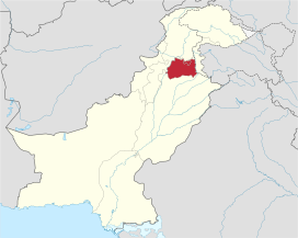
The Pothohar Plateau (Punjabi: پوٹھوہار پٹھار, romanized: Pо̄ṭhoā̀r Paṭhār; Urdu: سطح مرتفع پوٹھوہار, romanized: Satāh Murtafā Pо̄ṭhohār), also spelled Pothwar, is a plateau in the Sind Sagar Doab of northern Punjab, Pakistan, located between the Indus and Jhelum rivers.[1][2]
- ^ a b Tikekar, Maneesha (2004). Across the Wagah: An Indian's Sojourn in Pakistan. Bibliophile South Asia. p. 180. ISBN 978-81-85002-34-7.
- ^ a b Öztürk, Münir Ahmet; Khan, Shujaul Mulk; Altay, Volkan; Efe, Recep; Egamberdieva, Dilfuza; Khassanov, Furkat O. (2022). Biodiversity, Conservation and Sustainability in Asia: Volume 2: Prospects and Challenges in South and Middle Asia. Springer Nature. p. 912. ISBN 978-3-030-73943-0.

