Back Puerto Francisco de Orellana BAR Puerto Francisco de Orellana CEB Puerto Francisco de Orellana German Puerto Francisco de Orellana EO El Coca Spanish پورتو فرانسیسکو د ارللنا FA Puerto Francisco de Orellana French Puerto Francisco de Orellana Italian 푸에르토프란시스코데오레야나 Korean Puerto Fransisko de Oreljana LT
Puerto Francisco de Orellana
(El Coca) | |
|---|---|
City | |
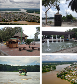
 From top, left to right: Panoramic view of the city, monument to Francisco de Orellana, Puerto Francisco de Orellana Boardwalk, Child's Park, canoe down the Napo River and Napo River Bridge. | |
| Coordinates: 00°27′45″S 76°59′03″W / 0.46250°S 76.98417°W[1] | |
| Country | |
| Province | |
| Canton | Francisco de Orellana Canton |
| Area | |
• City | 16.72 km2 (6.46 sq mi) |
| Elevation | 300 m (1,000 ft) |
| Population (2022 census)[2] | |
• City | 51,281 |
| • Density | 3,100/km2 (7,900/sq mi) |
| Demonym | Orellanese |
| Time zone | ECT |
| Area code | (+593) 6 |
| Climate | Af |
| Website | www.orellana.gob.ec (in Spanish) |
Puerto Francisco de Orellana (Spanish pronunciation: [ˈpweɾto fɾanˈsisko ðe oɾeˈʝana]), also known as El Coca (pronounced [el ˈkoka]), is the capital of province of Orellana in eastern Ecuador. The city is located in the Amazon Rainforest at the confluence of the Coca River and the Napo River (the smaller Payamino River also merges into the Napo in the city). It has a population of 51,281 as of 2022.[2] It is visited by tourists traveling into the rainforest and is served by the Francisco de Orellana Airport.
- ^ Puerto Francisco de Orellana, Orellana, Ecuador at GEOnet Names Server. Retrieved 7 November 2009.
- ^ a b Citypopulation.de Population and area of Puerto Francisco de Orellana

