Back Ketam adası AZ Pulau Ketam (pulo sa Malaysiya, lat 3,03, long 101,25) CEB Isla Ketam Spanish Pulau Ketam Finnish Pulau Ketam French Pulau Ketam Malay Pulau Ketam Polish Кетам Russian கெத்தாம் தீவு Tamil 吉胆岛 Chinese
Native name: Pulau Ketam ڤولاو کتم | |
|---|---|
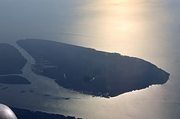
 Pulau Ketam in 2023 | |
 | |
| Geography | |
| Location | Strait of Malacca |
| Coordinates | 3°2′18.5″N 101°14′48.8″E / 3.038472°N 101.246889°E |
| Area | 22.921[1] km2 (8.850 sq mi) |
| Administration | |
| State | |
| District | Klang |
| Mukim | Klang |
| Demographics | |
| Population | 2,000[2] (2016) |
| Ethnic groups | Majority Chinese (Hokkien, Teochew and Hainanese) with minority Malays, Mah Meri and Temuan[3] |
Pulau Ketam ("Crab Island", Jawi: ڤولاو کتم, simplified Chinese: 吉胆岛; traditional Chinese: 吉膽島; pinyin: Jídǎn Dǎo) is an island located off the coast of Port Klang, Selangor, Malaysia. The island is in the intertidal zone and the chief vegetation is mangrove.
- ^ "CRAB ISLAND (PULAU KETAM)". Retrieved 15 March 2018.
- ^ Brenda Ch'ng. "Going back to basics in Pulau Ketam". The Star Online. Retrieved 15 March 2018.
- ^ "Ramadan on the ocean waves". 29 April 2021.