Back ريدينج (ماساتشوستس) Arabic ریدینق، ماساچوست AZB Reading (Massachusetts) Catalan Рединг (Массачусетс) CE Reading (lungsod sa Tinipong Bansa, Massachusetts) CEB Reading, Massachusetts CY Reading (Massachusetts) German Reading (Massachusetts) Spanish Reading (Massachusetts) EU ریدینگ، ماساچوست FA
Reading, Massachusetts | |
|---|---|
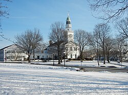
 Downtown Reading in March 2014 | |
 Location of Reading in Middlesex County, Massachusetts (left) and of Middlesex County in Massachusetts (right) | |
| Coordinates: 42°31′32″N 71°05′45″W / 42.52556°N 71.09583°W | |
| Country | United States |
| State | Massachusetts |
| County | Middlesex |
| Settled | 1644 |
| Named for | Reading, England |
| Government | |
| • Type | Representative town meeting |
| Area | |
• Total | 9.9 sq mi (25.7 km2) |
| • Land | 9.9 sq mi (25.7 km2) |
| • Water | 0.0 sq mi (0.0 km2) |
| Elevation | 127 ft (39 m) |
| Population (2020) | |
• Total | 25,518 |
| • Density | 2,600/sq mi (990/km2) |
| Time zone | UTC-5 (Eastern) |
| • Summer (DST) | UTC-4 (Eastern) |
| ZIP Code | 01867 |
| Area code | 339 / 781 |
| FIPS code | 25-56130 |
| GNIS feature ID | 0618232 |
| Website | http://www.ci.reading.ma.us/ |
Reading (/ˈrɛdɪŋ/ ⓘ RED-ing) is a town in Middlesex County, Massachusetts, United States, 16 miles (26 km) north of central Boston. The population was 25,518 at the 2020 census.[1]
- ^ "Census - Geography Profile: Reading town, Middlesex County, Massachusetts". United States Census Bureau. Retrieved September 29, 2021.
