  | |
|---|---|
| West 57th Avenue | |
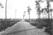
 Red Road in Coral Gables, 1921 | |
| Maintained by | FDOT |
| Length | 20.6 mi (33.2 km)[1] Two non-contiguous segments interrupted by Miami International Airport |
| Location | Miami-Dade, Broward |
| South end | South 136th Street / Howard Drive in Coral Gables |
| North end | |
| Construction | |
| Inauguration | 1921 |
Red Road, also known as West 57th Avenue, is a 20.6-mile (33.2 km) main north-south street running west of downtown Miami in Miami-Dade County, Florida and into Broward County. Red Road is signed as State Road 959 from U.S. 1 to the south end of the Miami International Airport, and State Road 823 from U.S. 27 to the Broward County line.
- ^ Florida Department of Transportation. "FDOT GIS data". Retrieved June 27, 2007.
