Back Рединг (Кънектикът) Bulgarian Redding (Connecticut) Catalan Реддинг (Коннектикут) CE Redding, Connecticut CY Redding (Connecticut) German Redding (Konektikuto) EO Redding (Connecticut) Spanish Redding (Connecticut) EU Redding (Connecticut) French Redding, Connecticut HT
Redding, Connecticut | |
|---|---|
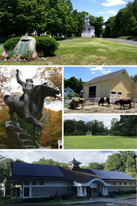
 Clockwise from top: Town Center; New Pond Farm; Redding Green; Mark Twain Library; Equestrian statue of Israel Putnam at Putnam Memorial State Park | |
| Coordinates: 41°18′16″N 73°23′34″W / 41.30444°N 73.39278°W | |
| Country | United States |
| U.S. state | Connecticut |
| County | Fairfield |
| Region | Western CT |
| Incorporated | 1767 |
| Villages/Sections | Redding Center Diamond Hill Five Points Georgetown (part) Redding Ridge Sanfordtown Topstone West Redding |
| Government | |
| • Type | Selectman-town meeting |
| • First selectman | Julia Pemberton (D) |
| • Selectman | Michael Thompson (R) |
| • Selectman | Peg O'Donnell (D) |
| Area | |
• Total | 32.1 sq mi (83.1 km2) |
| • Land | 31.5 sq mi (81.6 km2) |
| • Water | 0.6 sq mi (1.4 km2) |
| Elevation | 472 ft (144 m) |
| Population (2020) | |
• Total | 8,765 |
| • Density | 278.3/sq mi (107.5/km2) |
| Time zone | UTC-5 (Eastern) |
| • Summer (DST) | UTC-4 (Eastern) |
| ZIP Code | 06896 |
| Area code(s) | 203/475 |
| FIPS code | 09-63480 |
| GNIS feature ID | 0213495 |
| Website | www |
Redding is a town in Fairfield County, Connecticut, United States. The population was 8,765 at the 2020 census.[1] The town is part of the Western Connecticut Planning Region.
- ^ "Census - Geography Profile: Redding town, Fairfield County, Connecticut". United States Census Bureau. Retrieved December 20, 2021.


