Back نهر برينت ARZ Brent çayı AZ Riu Brent Catalan River Brent German Río Brent Spanish رود برنت FA Brent (rivière) French Brent (fiume) Italian Brent-elva NN Brent (elv) NB
This article needs additional citations for verification. (July 2015) |
| Brent | |
|---|---|
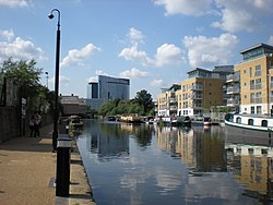
 River Brent at Brentford | |
 | |
| Location | |
| Country | England |
| Counties | Greater London |
| Districts / Boroughs | London Borough of Barnet, London Borough of Brent, London Borough of Ealing, London Borough of Hounslow |
| Towns | Hendon, Neasden, Perivale, Greenford, Hanwell |
| Physical characteristics | |
| Source | |
| • location | London Borough of Barnet, Greater London |
| Mouth | River Thames |
• location | Brentford, Greater London |
| Length | 29 km (18 mi) |
| Discharge | |
| • location | Costons Lane, Greenford |
| • average | 1.32 m3/s (47 cu ft/s) |
| • minimum | 0.19 m3/s (6.7 cu ft/s)3 August 1995 |
| • maximum | 42.9 m3/s (1,510 cu ft/s)12 October 1993 |
| Discharge | |
| • location | Monks Park |
| • average | 1.00 m3/s (35 cu ft/s) |
| Discharge | |
| • location | Brent Cross |
| • average | 0.34 m3/s (12 cu ft/s) |
| Basin features | |
| Tributaries | |
| • left | Dollis Brook, Decoy Brook, Clitterhouse Brook, Silk Stream, Wealdstone Brook, Gadder brook |
| • right | Mutton Brook, Peggy Back's (subterranean) drain |
The River Brent is a river in west and northwest London, England, and a tributary of the River Thames. 17.9 miles (28.8 km) in length, it rises in the Borough of Barnet and flows in a generally south-west direction before joining the Tideway stretch of the Thames at Brentford.[1]
- ^ Baxter, Alan (January 2011). "11. Brent River Valley". London's Natural Signatures: The London Landscape Framework (PDF). pp. 74–77. Archived from the original (PDF) on 4 September 2012. Retrieved 29 September 2021.