Back River Nidd CEB ریور نید FA Nidd (rivier) Dutch Nidd Polish Nidd SH Нид (река у Енглеској) Serbian River Nidd Swedish Ревир нид TG
| River Nidd | |
|---|---|
 | |
| Etymology | Probably a Celtic word meaning "bright, brilliant, shining" |
| Location | |
| Country | England |
| Physical characteristics | |
| Source | |
| • location | Nidd Head Spring, 1.3 km north of the summit of Great Whernside |
| • elevation | 595 metres (1,952 ft) |
| Mouth | |
• location | River Ouse, Nun Monkton |
• coordinates | 54°0′51″N 1°13′8″W / 54.01417°N 1.21889°W |
• elevation | 13 metres (43 ft) |
| Length | 94.45 kilometres (58.69 mi) |
| Basin size | 516 square kilometres (199 sq mi) |
| Basin features | |
| River system | Swale–Ouse |
River Nidd | |||||||||||||||||||||||||||||||||||||||||||||||||||||||||||||||||||||||||||||||||||||||||||||||||||||||||||||||||||||||||||||||||||||||||||||||||||||||||||||||||||||||||||||||||||||||||||||||||||||||||||||||||||||||||||||||||||||||||||||||||||||||||||||||||||||||||||||||||||||||||||||||||||||||||||||||||||||||||||||||||||||||||||||||||||||||||||||||||||||||||||||||||||||||||||||||||||||||||||||||||||||||||||||||||||||||||||||||||||||||||||||||||||||||||||||||||||||||||||||||||||
|---|---|---|---|---|---|---|---|---|---|---|---|---|---|---|---|---|---|---|---|---|---|---|---|---|---|---|---|---|---|---|---|---|---|---|---|---|---|---|---|---|---|---|---|---|---|---|---|---|---|---|---|---|---|---|---|---|---|---|---|---|---|---|---|---|---|---|---|---|---|---|---|---|---|---|---|---|---|---|---|---|---|---|---|---|---|---|---|---|---|---|---|---|---|---|---|---|---|---|---|---|---|---|---|---|---|---|---|---|---|---|---|---|---|---|---|---|---|---|---|---|---|---|---|---|---|---|---|---|---|---|---|---|---|---|---|---|---|---|---|---|---|---|---|---|---|---|---|---|---|---|---|---|---|---|---|---|---|---|---|---|---|---|---|---|---|---|---|---|---|---|---|---|---|---|---|---|---|---|---|---|---|---|---|---|---|---|---|---|---|---|---|---|---|---|---|---|---|---|---|---|---|---|---|---|---|---|---|---|---|---|---|---|---|---|---|---|---|---|---|---|---|---|---|---|---|---|---|---|---|---|---|---|---|---|---|---|---|---|---|---|---|---|---|---|---|---|---|---|---|---|---|---|---|---|---|---|---|---|---|---|---|---|---|---|---|---|---|---|---|---|---|---|---|---|---|---|---|---|---|---|---|---|---|---|---|---|---|---|---|---|---|---|---|---|---|---|---|---|---|---|---|---|---|---|---|---|---|---|---|---|---|---|---|---|---|---|---|---|---|---|---|---|---|---|---|---|---|---|---|---|---|---|---|---|---|---|---|---|---|---|---|---|---|---|---|---|---|---|---|---|---|---|---|---|---|---|---|---|---|---|---|---|---|---|---|---|---|---|---|---|---|---|---|---|---|---|---|---|---|---|---|---|---|---|---|---|---|---|---|---|---|---|---|---|---|---|---|---|---|---|---|---|---|---|---|---|---|---|---|---|---|---|---|---|---|---|---|---|---|---|---|---|---|---|---|---|---|---|---|---|---|---|---|---|---|---|---|---|---|---|---|---|---|---|---|---|---|---|---|---|---|---|---|---|---|---|---|---|---|---|---|---|---|---|---|---|---|---|---|---|---|---|---|---|---|---|---|---|---|---|---|---|---|
| |||||||||||||||||||||||||||||||||||||||||||||||||||||||||||||||||||||||||||||||||||||||||||||||||||||||||||||||||||||||||||||||||||||||||||||||||||||||||||||||||||||||||||||||||||||||||||||||||||||||||||||||||||||||||||||||||||||||||||||||||||||||||||||||||||||||||||||||||||||||||||||||||||||||||||||||||||||||||||||||||||||||||||||||||||||||||||||||||||||||||||||||||||||||||||||||||||||||||||||||||||||||||||||||||||||||||||||||||||||||||||||||||||||||||||||||||||||||||||||||||||
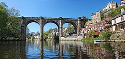
The River Nidd is a tributary of the River Ouse in the English county of North Yorkshire. It rises in Nidderdale at Nidd Head Spring on the slopes of Great Whernside. In its first few miles it has been dammed three times, creating Angram Reservoir, Scar House Reservoir and Gouthwaite Reservoir, which attract a total of around 150,000 visitors a year.[1] It joins the River Ouse at Nun Monkton.
The upper river valley, Nidderdale, was designated as an Area of Outstanding Natural Beauty in 1994.[2]
The Yorkshire Dales Rivers Trust has a remit to conserve the ecological condition of the River Nidd from its headwaters to the Humber estuary.
- ^ "Scar House Reservoir". www.yorkshireguides.com. Retrieved 22 June 2017.
- ^ "York & North Yorkshire – Wading birds need landowners' help". BBC News. 27 October 2009. Retrieved 22 June 2017.

