Riverina Highway | |
|---|---|
 | |
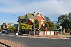
| Riverina Highway through Berrigan (as Chanter Street, where it meets Jerilderie Street) | |
 | |
| General information | |
| Type | Highway |
| Length | 220 km (137 mi)[1] |
| Gazetted | August 1928 (as Main Road 212)[2] March 1938 (as State Highway 20)[3] |
| Route number(s) | (East Albury–Deniliquin) |
| Former route number | Entire route |
| Major junctions | |
| East end | Hume Weir, New South Wales |
| West end | Deniliquin, New South Wales |
| Location(s) | |
| Major settlements | Albury, Howlong, Berrigan, Finley |
| Highway system | |
| ---- | |
Riverina Highway is a 220-kilometre (140 mi)-long[1] state highway located in the Riverina region of New South Wales, Australia.[4] The road was constructed over several decades with final asphalt concrete sealing completed during the 1960s.[5]
- ^ a b "Riverina Highway" (Map). Google Maps. Retrieved 17 August 2022.
- ^ "Main Roads Act, 1924-1927". Government Gazette of the State of New South Wales. No. 110. 17 August 1928. pp. 3814–20. Archived from the original on 3 August 2022. Retrieved 1 August 2022 – via National Library of Australia.
- ^ "Main Roads Act, 1924-1937". Government Gazette of the State of New South Wales. No. 46. National Library of Australia. 25 March 1938. p. 1223. Archived from the original on 6 September 2022. Retrieved 6 September 2022.
- ^ Riverina Highway, Ozroads: the Australian Roads Website. Retrieved 25 May 2008.[self-published source]
- ^ "Reconstruction of the Riverina Highway Site Tour". Engineers Australia. March 2016. Retrieved 11 November 2016.
