| Rosewater Adelaide, South Australia | |||||||||||||||
|---|---|---|---|---|---|---|---|---|---|---|---|---|---|---|---|
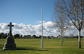
 Eric Sutton Oval | |||||||||||||||
| Coordinates | 34°51′14″S 138°31′13″E / 34.853865°S 138.520145°E[1] | ||||||||||||||
| Population | 3,582 (SAL 2021)[2] | ||||||||||||||
| Established | 1855 | ||||||||||||||
| Postcode(s) | 5013 | ||||||||||||||
| Area | 1.4 km2 (0.5 sq mi) | ||||||||||||||
| Time zone | ACST (UTC+9:30) | ||||||||||||||
| • Summer (DST) | ACST (UTC+10:30) | ||||||||||||||
| Location | 12 km (7 mi) NW of Adelaide city centre | ||||||||||||||
| LGA(s) | |||||||||||||||
| Region | Western Adelaide [1] | ||||||||||||||
| County | Adelaide | ||||||||||||||
| State electorate(s) | Cheltenham Port Adelaide | ||||||||||||||
| Federal division(s) | Hindmarsh | ||||||||||||||
| |||||||||||||||
| Footnotes | Adjoining suburbs[1] | ||||||||||||||
Rosewater is one of the western suburbs of Adelaide and is located 10 km north-west of Adelaide's central business district. Although mainly residential, there are many shops along Grand Junction Road and the closed Rosewater Loop railway line runs through the suburb. Rosewater is split in half by Grand Junction Road and bordered on the east by Addison Road, and on the south by Torrens Road.
Originally, the area was mainly used as vegetable and dairy farmland but became more and more residential as the railway lines and Grand Junction Road were completed and as Port Adelaide grew and developed. Rosewater was also the site of the AdelaideRadio (VIA) maritime radio station system from 1912 to 1963.[3]
- ^ a b c "Search results for 'Rosewater, SUB' with the following datasets selected - 'Suburbs and localities', 'Counties', 'Local Government Areas', 'SA Government Regions' and 'Gazetteer'". Location SA Map Viewer. Government of South Australia. Retrieved 22 April 2024.
- ^ Australian Bureau of Statistics (28 June 2022). "Rosewater (suburb and locality)". Australian Census 2021 QuickStats. Retrieved 28 June 2022.
- ^ Adelaide Radio (VIA)

