Back منطقة سنغالي Arabic سانجالى ARZ सांगली जिला BH সাংলী জেলা Bengali/Bangla Sangli (distrito sa Indiya) CEB Sangli (Distrikt) German Distrito de Sangli Spanish Sangli barrutia EU بخش سنگلی FA District de Sangli French
This article needs additional citations for verification. (June 2019) |
Sangli district | |
|---|---|
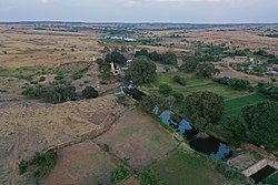
Top: Ganapati Mandir, Sangli Bottom: View of Khalati village | |
 Location in Maharashtra | |
| Country | |
| State | |
| Division | Pune |
| Headquarters | Sangli |
| Talukas | |
| Government | |
| • Body | Sangli Zilla Parishad |
| • Guardian Minister | Suresh Khade (Cabinet Minister MH) |
| • President Z. P. Sangli | NA |
| • District Collector | Mr. Dr. Raja dayanidhi IAS |
| • CEO Z. P. Sangli | NA |
| • MPs | Vishal Patil (Sangli) Dhairyasheel Sambhajirao Mane (Hatkanangle) |
| Area | |
• Total | 8,572 km2 (3,310 sq mi) |
| Population (2023) | |
• Total | 3,139,974 |
| • Density | 370/km2 (950/sq mi) |
| • Urban | 31.11% |
| Demographics | |
| • Literacy | 82.62 %[1] |
| • Sex ratio | 981[1] |
| Time zone | UTC+05:30 (IST) |
| Major highways | NH-4, NH-204 |
| Average annual precipitation | 400–450 mm |
| Website | sangli |
Sangli district (Marathi pronunciation: [saːŋɡli]) is a district of Maharashtra state in India. Sangli city is the district headquarters. It is bordered by Satara district, Solapur district to the North, Karnataka state to the South-East, by Kolhapur district to South-West and by narrow portion on the East side to Ratnagiri district. It is present on the southern tip of Maharashtra.[1]
The district is 31.11% urban. Sangli and Miraj are the largest cities.[citation needed] The second oldest industrial township like Kirloskarwadi (Palus) is also located in Sangli district. Industrialist Laxmanrao Kirloskar started his first factory here. It is known as the sugar bowl of India due to its high sugarcane productivity. Sangli district is one of the most fertile and highly developed districts in Maharashtra. The district is very popular as a political powerhouse in the state. It has provided many politicians and bureaucrats and is often referred to as the Heaven of Farmers.[This paragraph needs citation(s)]


