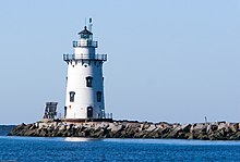
 Saybrook Breakwater Light | |
 | |
| Location | Old Saybrook Connecticut United States |
|---|---|
| Coordinates | 41°15′47.68″N 72°20′34″W / 41.2632444°N 72.34278°W |
| Tower | |
| Constructed | 1886 |
| Foundation | cast iron and concrete caisson |
| Construction | sparkplug lighthouse |
| Automated | 1959 |
| Height | 48 feet (15 m) |
| Shape | 2-stages cylindrical tower with double balcony and lantern incorporating keeper's quarter |
| Power source | solar power |
| Operator | United States Coast Guard[1] [2] |
| Heritage | National Register of Historic Places listed place |
| Light | |
| Focal height | 58 feet (18 m) |
| Lens | Fifth order Fresnel lens (original), 300 mm lens (current) |
| Characteristic | Fl G 6s. |
Saybrook Breakwater Lighthouse | |
| Location | S terminus of Saybrook Jetty at mouth of Connecticut River, Old Saybrook, Connecticut |
| Area | less than one acre |
| Built | 1886 |
| Architect | Smith, G.W. & F. Iron Co. |
| MPS | Operating Lighthouses in Connecticut MPS |
| NRHP reference No. | 89001474[3] |
| Added to NRHP | May 29, 1990 |
Saybrook Breakwater Lighthouse is a sparkplug lighthouse in Connecticut, United States, at Fenwick Point at the mouth of the Connecticut River near Old Saybrook, Connecticut. It is featured[4] on the state's "Preserve the Sound" license plates.
"That outer lighthouse is the symbol of Old Saybrook," town First Selectman Michael Pace said in 2007, when the town was making plans to buy the lighthouse from the federal government.[4]
The lighthouse is also known simply as "Breakwater Light" or "Outer Light". It is one of two built off Lynde Point in the nineteenth century. The other lighthouse, known as Lynde Point Light or more commonly as "Inner Light", is 75 years older than this lighthouse. The two lighthouses mark the harbor channel at the mouth of the Connecticut River.[4]
- ^ Rowlett, Russ. "Lighthouses of the United States: Connecticut". The Lighthouse Directory. University of North Carolina at Chapel Hill. Retrieved 2016-06-22.
- ^ Connecticut Historic Light Station Information & Photography United States Coast Guard. Retrieved 22 June 2016
- ^ "National Register Information System". National Register of Historic Places. National Park Service. July 9, 2010.
- ^ a b c Associated Press news article, titled "Old Saybrook lighthouse for sale for $1" in The Advocate of Stamford, Connecticut, August 7, 2007, page A4
