Back مقاطعة شويلر (نيويورك) Arabic Schuyler County, New York BAR Шуйлър (окръг, Ню Йорк) Bulgarian স্কুইলের কাউন্টি, নিউ ইয়র্ক BPY Schuyler Gông (New York) CDO Скайлер (гуо, Нью-Йорк) CE Schuyler County (kondado sa Tinipong Bansa, New York) CEB Schuyler County (New York) Czech Schuyler County, Efrog Newydd CY Schuyler County (New York) German
Schuyler County | |
|---|---|
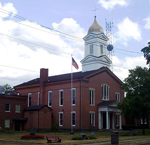
 Schuyler County Courthouse | |
 Location within the U.S. state of New York | |
 New York's location within the U.S. | |
| Coordinates: 42°23′N 76°53′W / 42.39°N 76.88°W | |
| Country | |
| State | |
| Founded | 1854 |
| Named for | Philip Schuyler |
| Seat | Watkins Glen |
| Largest community | Watkins Glen |
| Area | |
• Total | 342 sq mi (890 km2) |
| • Land | 328 sq mi (850 km2) |
| • Water | 14 sq mi (40 km2) 4.1% |
| Population (2020) | |
• Total | 17,898 [1] |
| • Density | 54.5/sq mi (21.0/km2) |
| Time zone | UTC−5 (Eastern) |
| • Summer (DST) | UTC−4 (EDT) |
| Congressional district | 23rd |
| Website | www |
Schuyler County is a county in the U.S. state of New York. As of the 2020 census, the population was 17,898,[2] making it the second-least populous county in New York. The county seat is the village of Watkins Glen.[3] The name is in honor of General Philip Schuyler, one of the four major generals in the Continental Army in the American Revolutionary War. The county is part of the Southern Tier region of the state.
- ^ "US Census 2020 Population Dataset Tables for New York". United States Census Bureau. Retrieved January 2, 2022.
- ^ "U.S. Census Bureau QuickFacts: Schuyler County, New York". United States Census Bureau. Archived from the original on June 7, 2011. Retrieved January 2, 2022.
- ^ "Find a County". National Association of Counties. Retrieved June 7, 2011.

