Back شو لو Arabic شو لو (تجمع سكان فى مقاطعه نافاهو) ARZ شوو لوو، آریزونا AZB Шоу Лоу Bulgarian Show Low Catalan Шоу-Лоу CE Show Low CEB Show Low, Arizona CY Show Low German Show Low Spanish
Show Low | |
|---|---|
 | |
| Motto: "Named By The Turn Of A Card" | |
 Location of Show Low in Navajo County, Arizona | |
| Coordinates: 34°14′37″N 110°02′53″W / 34.24361°N 110.04806°W | |
| Country | United States |
| State | Arizona |
| County | Navajo |
| Founded | 1870 |
| Incorporated | 1953 |
| Government | |
| • Type | Council–Manager |
| • Body | Show Low City Council |
| • Mayor | John Leech[citation needed] |
| Area | |
• Total | 65.98 sq mi (170.88 km2) |
| • Land | 65.50 sq mi (169.66 km2) |
| • Water | 0.47 sq mi (1.23 km2) |
| Elevation | 6,349 ft (1,935 m) |
| Population (2020) | |
• Total | 11,732 |
| • Density | 179.10/sq mi (69.15/km2) |
| Time zone | UTC−7 (Mountain) |
| • Summer (DST) | UTC−7 (no DST/PDT) |
| ZIP Codes | 85901, 85902, 85911 |
| Area code | 928 |
| FIPS code | 04-66470 |
| GNIS ID(s) | 2411895[2] |
| Major airport | Show Low Regional Airport |
| U.S. Highways | |
| State Routes | |
| Website | www |
| U.S. Decennial Census[3] | |
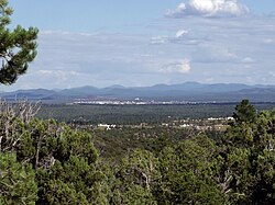
Show Low is a city in Navajo County, Arizona. It lies on the Mogollon Rim in east central Arizona, at an elevation of 6,345 feet (1,934 m). The city was established in 1870 and incorporated in 1953. According to the 2020 census, the population of the city was 11,732.[4]
- ^ "2020 U.S. Gazetteer Files". United States Census Bureau. Retrieved October 29, 2021.
- ^ a b U.S. Geological Survey Geographic Names Information System: Show Low, Arizona
- ^ Cite error: The named reference
DecennialCensuswas invoked but never defined (see the help page). - ^ "U.S. Census website". United States Census Bureau. Retrieved June 18, 2024.

