Back Simcoe County CEB Simcoe County German شهرستان سیمکو FA Comté de Simcoe French Contea di Simcoe Italian シムコー郡 Japanese Hrabstwo Simcoe Polish سمکو کاؤنٹی PNB Condado de Simcoe Portuguese Simcoe County SIMPLE
Simcoe County | |
|---|---|
| County of Simcoe | |
Clockwise from top left: Wasaga Beach, Collingwood Town Hall, straw bales near Alliston, The Martyrs' Shrine, Minesing Wetlands, Oro African Church | |
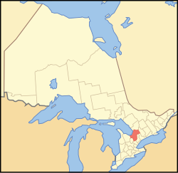
 Map showing Simcoe County's location in Ontario | |
| Coordinates: 44°35′N 79°44′W / 44.583°N 79.733°W | |
| Country | |
| Province | |
| Established | 1843 (as Simcoe District) |
| County seat | Midhurst |
| Subdivisions | List
|
| Government | |
| • Type | Upper Tier municipality |
| • Council | Simcoe County Council |
| Area | |
| • Land | 4,691.39 km2 (1,811.36 sq mi) |
| • Census div. | 4,818.93 km2 (1,860.60 sq mi) |
| Land area excludes Barrie and Orillia | |
| Population | |
• Total | 351,929 |
| • Density | 75.0/km2 (194/sq mi) |
| • Census div. | 533,169 |
| • Census div. density | 110.6/km2 (286/sq mi) |
| Total excludes Barrie and Orillia | |
| Demonym | Simcoe Countian |
| Time zone | UTC-5 (EST) |
| • Summer (DST) | UTC-4 (EDT) |
| Area code(s) | 705 and 249 |
| Website | www |
Simcoe County is a county and census division located in the central region of Ontario, Canada. The county is located north of the Greater Toronto Area, and forms the north western edge of the Golden Horseshoe. The county seat is located in Midhurst. The cities of Barrie and Orillia are geographically within Simcoe County, but are both politically independent single-tier municipalities.
- ^ a b "Census Profile, 2021 Census: Simcoe, County [Census division], Ontario". Statistics Canada. 9 February 2022. Retrieved June 21, 2022.


