Back جبل ياسجيريد فاور ARZ Skirrid Fawr CEB Ysgyryd Fawr CY Ysgyryd Fawr German Skirrid Fawr Swedish
| Skirrid Fawr | |
|---|---|
| Ysgyryd Fawr | |
 Ysgyryd Fawr from the northwest | |
| Highest point | |
| Elevation | 486 m (1,594 ft) |
| Prominence | 344 m (1,129 ft) |
| Parent peak | Sugar Loaf |
| Listing | Marilyn |
| Coordinates | 51°51′30″N 2°58′15″W / 51.858386°N 2.970816°W |
| Naming | |
| English translation | Great shattered [hill] |
| Language of name | Welsh |
| Pronunciation | Welsh: [ɐsˈɡɐɾɪd ˈvæuɾ] |
| Geography | |
| Parent range | Black Mountains |
| OS grid | SO331182 |
| Topo map | OS Landranger 161 |
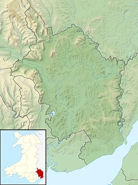
Skirrid Fawr (Welsh: Ysgyryd Fawr , Welsh pronunciation: [ɐsˈɡɐɾɪd ˈvæuɾ]), often referred to as just the Skirrid, is a traditional Christian pilgrimage site and an easterly outlier of the Black Mountains in Wales.[1] It forms the easternmost part of the Brecon Beacons National Park. The smaller hill of Ysgyryd Fach or "Little Skirrid" (270 metres or 890 feet) lies about 2+1⁄2 miles (4 kilometres) south.
It is 486 metres (1,594 feet) high and lies just to the north-east of Abergavenny, Monmouthshire, about ten miles (16 kilometres) from the English border. The Beacons Way passes along the ridge.[2]
- ^ "The Skirrid trail │ Abergavenny │ Wales". National Trust. Retrieved 18 July 2023.
- ^ "Beacons Way". Brecon Beacons National Park Authority.
