Back South Bank Parkland CEB South Bank Parklands French 사우스뱅크 파크랜드 Korean South Bank Parkland Swedish 南岸公園 Chinese
| South Bank Parklands | |
|---|---|
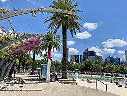
 Streets Beach and Grand Arbour, South Bank Parklands | |
 | |
| Location | South Brisbane, Brisbane, Queensland, Australia |
| Coordinates | 27°28′43″S 153°01′22″E / 27.4787°S 153.0229°E |
| Area | 17.5 hectares (0.068 sq mi) |
| Opened | 20 June 1992[1] |
| Open | 5:00 am - midnight |
| Status | Open all year |
| Parking | 800 spaces |
| Public transit access | Train, bus and ferry |
| Website | www |
The South Bank Parklands are located at South Bank within the suburb of South Brisbane in Brisbane, Queensland, Australia. The parkland, on the transformed site of Brisbane's World Expo 88, was officially opened to the public on 20 June 1992.[1]
The South Bank Parklands are located on the southern bank of the Brisbane River, at South Bank, directly opposite the City. The parklands are connected to the City by the Victoria Bridge at the northern end, and to Gardens Point by the Goodwill Bridge at the southern end.
The parklands consist of a mixture of rainforest, water, grassed areas and plazas as well as features such as the riverfront promenade, the Streets Beach, the Grand Arbour, the Courier Mail Piazza, the Nepalese Peace Pagoda, the Wheel of Brisbane, restaurants, shops and fountains. The parklands are also home to the Queensland Conservatorium.
South Bank and its parklands are one of Brisbane's most important cultural precincts and they regularly host large scale festivals and events. An estimated 14 million people visit the parklands each year, making it Australia's most visited landmark.[2]
- ^ a b John Stubbs (21 June 1992). "Brisbane's $100M Oasis Opens". The Sun-Herald (Queensland ed.). Sydney, Australia. p. 3. Archived from the original on 31 January 2022. Retrieved 21 May 2014.
- ^ "About South Bank | Visit Brisbane, Australia". visit.brisbane.qld.au. Archived from the original on 31 January 2024. Retrieved 6 March 2024.