Back Саут Хамс (община) Bulgarian Su Hams BR South Hams District CEB Ardal South Hams CY South Hams German South Hams Spanish South Hams French South Hams Italian 사우스햄스 Korean Dienvidhemsa Latvian/Lettish
South Hams | |
|---|---|
 | |
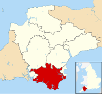
 South Hams shown within Devon | |
| Coordinates (Totnes): 50°25′53″N 3°41′28″W / 50.43139°N 3.69111°W | |
| Sovereign state | United Kingdom |
| Constituent country | England |
| Region | South West England |
| Non-metropolitan county | Devon |
| Formed | 1 April 1974 |
| Government | |
| • Type | District council |
| • Body | South Hams District Council |
| • HQ | Totnes |
| • Sub-divisions | Civil parishes |
| • UK Parliament | South West Devon South Devon |
| • MPs | Rebecca Smith (C) Caroline Voaden (LD) |
| Area | |
• Total | 342.28 sq mi (886.51 km2) |
| • Rank | Ranked 36th |
| Population (2022) | |
• Total | 89,812 |
| • Rank | Ranked 264th |
| • Density | 260/sq mi (101/km2) |
| • Ethnicity | 99.09% White |
| ONS code | 18UG |
South Hams is a local government district on the south coast of Devon, England. Its council is based in the town of Totnes, although the largest town is Ivybridge. The district also contains the towns of Dartmouth, Kingsbridge and Salcombe and numerous villages and surrounding rural areas.
Much of the district's landscape is recognised for its natural beauty; the north of the district includes part of Dartmoor National Park, the district's coastline and adjoining areas form most of the South Devon Area of Outstanding Natural Beauty, and part of the west of the district lies within the Tamar Valley AONB. The district's coast includes the promontories of Start Point and Bolt Head.
The neighbouring districts are Torbay, Teignbridge, West Devon, Cornwall (across the Tamar–Tavy Estuary) and Plymouth.