| South Pennines Regional Park | |
|---|---|
 | |
 | |
| Coordinates | 53°44′24″N 2°03′29″W / 53.740°N 2.058°W |
| Area | 460 square miles (1,200 km2) |
| Elevation | 1,873 feet (571 m) |
| Created | 2021 |
| Website | Official website |
| UK National Parks |
|---|
| Parentheses denotes the year. An area with ‡ has similar status to a UK National Park. Areas marked † are proposed. |
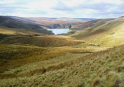
The South Pennines Regional Park (or South Pennines Park) was a proposed national park that would cover the South Pennines area in Northern England, encompassing parts of Greater Manchester, Lancashire and West Yorkshire. It would also adjoin the borders of two existing national parks; the Yorkshire Dales in the north and the Peak District in the south. The area was named as a prospective national park in the 1940s when the idea of creating national parks was being carried forward, but it was never given the same status as the Peak District, North York Moors or the Yorkshire Dales.
The South Pennines Regional Park was championed by many agencies and charities. Pennine Prospects were awarded Heritage Lottery Funding in 2018. In September 2021, the park was launched under a "self-declaration" scheme, though its status is not recognised by the Department for Environment, Food and Rural Affairs.
The organisation behind the proposal closed at the end of 2023.[1] The South Pennines is the only upland area of England without any designated protection framework.
- ^ "Organisation behind The South Pennines Park to close". 2024. Retrieved 15 January 2024.
