Back South Yarra German ساوث یارا، ویکتوریا FA South Yarra (Victoria) French South Yarra, Bhictòria GD South Yarra NB جنوبی یارا، وکٹوریہ UR
| South Yarra Melbourne, Victoria | |||||||||||||||
|---|---|---|---|---|---|---|---|---|---|---|---|---|---|---|---|
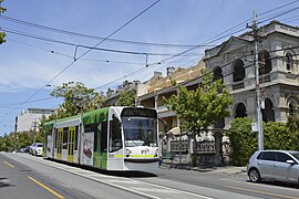
 South Yarra, 2016 | |||||||||||||||
 | |||||||||||||||
| Coordinates | 37°50′24″S 144°59′20″E / 37.840°S 144.989°E | ||||||||||||||
| Population | 25,028 (SAL 2021)[1] | ||||||||||||||
| Established | 1850s | ||||||||||||||
| Postcode(s) | 3141 | ||||||||||||||
| Elevation | 21 m (69 ft) | ||||||||||||||
| Area | 5 km2 (1.9 sq mi) | ||||||||||||||
| Location | 4 km (2 mi) from Melbourne CBD | ||||||||||||||
| LGA(s) | |||||||||||||||
| State electorate(s) | Prahran | ||||||||||||||
| Federal division(s) | |||||||||||||||
| |||||||||||||||
South Yarra is an inner-city suburb in Melbourne, Victoria, Australia, 4 km south-east of Melbourne's Central Business District, located within the Cities of Melbourne and Stonnington local government areas. South Yarra recorded a population of 25,028 at the 2021 census.[2]

Punt Road divides the suburb between Stonnington (east) and Melbourne (west). The main shopping region of South Yarra runs along Toorak Road and Chapel Street. Trade along these two arteries are focused on trendy and upmarket shopping, restaurants, nightclubs and cafe culture. The area of South Yarra centred along Commercial Road was for several decades one of Melbourne's gay villages.
South Yarra is also home to some of Melbourne's most prestigious residential addresses. Residential land price records (per square metre) have been set by properties in Domain Road, Walsh Street and Fairlie Court.
- ^ Australian Bureau of Statistics (28 June 2022). "South Yarra (suburb and locality)". Australian Census 2021 QuickStats. Retrieved 28 June 2022.
- ^ Australian Bureau of Statistics (28 June 2022). "South Yarra (Suburbs and Localities)". 2021 Census QuickStats. Retrieved 17 July 2022.
