Back سوتبوری، کانتیکت AZB Southbury Catalan Саутбери (Коннектикут) CE Southbury CEB Southbury, Connecticut CY Southbury German Southbury Spanish Southbury (Connecticut) EU ساوتبوری، کنتیکت FA Southbury French
Southbury, Connecticut | |
|---|---|
| Town of Southbury | |
 Southbury Town Hall | |
| Coordinates: 41°28′25″N 73°14′03″W / 41.47361°N 73.23417°W | |
| Country | |
| State | |
| County | New Haven |
| Region | Naugatuck Valley |
| Incorporated | 1787 |
| Government | |
| • Type | Selectman-town meeting |
| • First selectman | Jeff Manville (R) |
| • Selectmen | Jason Buchsbaum (R)
Justin Bette (D) Gregory Kuehn (R) Holly Sullivan (R) Tim O'Neil (D) |
| Area | |
• Total | 40.1 sq mi (103.8 km2) |
| • Land | 39.0 sq mi (101.0 km2) |
| • Water | 1.1 sq mi (2.8 km2) |
| Elevation | 335 ft (102 m) |
| Population (2020) | |
• Total | 19,879 |
| • Density | 500/sq mi (190/km2) |
| Time zone | UTC−5 (Eastern) |
| • Summer (DST) | UTC−4 (Eastern) |
| ZIP code | 06488 |
| Area code(s) | 203/475 |
| FIPS code | 09-69640 |
| GNIS feature ID | 0213507 |
| Website | www |
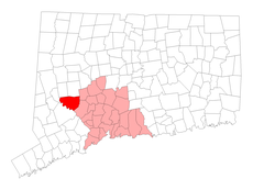
Southbury is a town in western New Haven County, Connecticut, United States. It is north of Oxford and Newtown, and east of Brookfield. Its population was 19,879 at the 2020 census.[1] The town is part of the Naugatuck Valley Planning Region.
Southbury comprises sprawling rural country areas, suburban neighborhoods, and historic districts. It is a short distance from major business and commercial centers. It is 67 miles (107 km) north of New York City, and 34 miles (54 km) south of Hartford.
Southbury is the only community in the country with the name "Southbury", which is why the town seal reads Unica Unaque, meaning "The One and Only."
- ^ "Census - Geography Profile: Southbury town, New Haven County, Connecticut". United States Census Bureau. Retrieved December 21, 2021.


