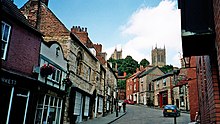
 View up 'Steep Hill' towards the historic quarter of Bailgate | |
| Former name(s) | Ermine Street, Iter VI of the Antonine Itinerary |
|---|---|
| Maintained by | Lincolnshire County Council |
| Length | 420 m (1,380 ft)[1] |
| Addresses | 1-65 |
| Location | Lincoln, England |
| Postal code | LN2 1LU |
| Coordinates | 53°13′58″N 0°32′18″W / 53.232684°N 0.538439°W |
| Uphill end | Bailgate 53°13′59″N 0°32′19″W / 53.233062°N 0.538486°W |
| Major junctions | Well Lane, Wordsworth Street, Michaelgate, Christ's Hospital Terrace |
| Downhill end | Danes Terrace, The Strait 53°13′56″N 0°32′19″W / 53.232084°N 0.538609°W |
| Construction | |
| Commissioned | Roman Empire |
| Construction start | 1st Century |
Steep Hill is a street in the historic city of Lincoln, Lincolnshire, England. At the top of the hill is the entrance to Lincoln Cathedral and at the bottom is Well Lane. The Hill consists of independent shops, tea rooms and public houses.
Its name arises from the gradient of the hill, which is difficult to ascend and descend. The hill has a one-in-seven (14%) gradient.[2]
- ^ "Google maps walking route". Retrieved 17 February 2011.
- ^ "Lincoln Steep Hill bus gets 11th hour rescue". BBC. Retrieved 29 October 2013.
