Back مقاطعة سوفولك (نيويورك) Arabic County Suffolk, New York BAN Suffolk County, New York BAR Съфолк (окръг, Ню Йорк) Bulgarian সাফোক কাউন্টি, নিউ ইয়র্ক BPY Suffolk Gông (New York) CDO Саффолк (гуо, Нью-Йорк) CE Suffolk County (kondado sa Tinipong Bansa, New York) CEB Suffolk County (New York) Czech Suffolk County, Efrog Newydd CY
Suffolk County | |
|---|---|
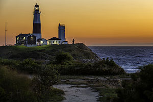
 Dawn over Montauk Point Light | |
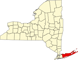
 Location within the U.S. state of New York | |
 New York's location within the U.S. | |
| Coordinates: 40°56′N 72°41′W / 40.94°N 72.68°W | |
| Country | |
| State | |
| Founded | 1683 |
| Named for | Suffolk, England |
| Seat | Riverhead |
| Largest town | Brookhaven |
| Government | |
| • Executive | Edward P. Romaine (R) |
| Area | |
• Total | 2,373 sq mi (6,150 km2) |
| • Land | 912 sq mi (2,360 km2) |
| • Water | 1,461 sq mi (3,780 km2) 62% |
| Population (2020) | |
• Total | 1,525,920 |
• Estimate (2022) | 1,525,465 |
| • Density | 1,673.16/sq mi (646.01/km2) |
| Time zone | UTC−5 (Eastern) |
| • Summer (DST) | UTC−4 (EDT) |
| Congressional districts | 1st, 2nd, 3rd |
| Website | www |
| [1] | |
| Part of a series on |
| Long Island |
|---|
 |
| Topics |
| Regions |
Suffolk County (/ˈsʌfək/ SUF-ək) is the easternmost county in the U.S. state of New York, constituting the eastern two-thirds of Long Island. It is bordered to its west by Nassau County, to its east by Gardiners Bay and the open Atlantic Ocean, to its north by Long Island Sound, and to its south by the Atlantic Ocean.
As of the 2020 United States census, the county's population was 1,525,920,[1] its highest decennial count ever, making Suffolk the fourth-most populous county in the State of New York, and the most populous outside of the boroughs of New York City. Its county seat is Riverhead,[2] though most county offices are in Hauppauge.[3] The county was named after the county of Suffolk in England, the origin of its earliest European settlers.
Suffolk County incorporates the easternmost extreme of both the New York City metropolitan area and New York State. The geographically largest of Long Island's four counties and the second-largest of New York's 62 counties, Suffolk County is 86 miles (138 km) in length and 26 miles (42 km) in width at its widest (including water).[4] Most of the island is near sea level, with over 1,000 miles of coastline.[5]
Like other parts of Long Island, the county's high population density and proximity to New York City has resulted in a diverse economy, including industry, science, agriculture, fishery, and tourism. Major scientific research facilities in Suffolk County include Brookhaven National Laboratory in Upton and Plum Island Animal Disease Center on Plum Island. The county is home to Stony Brook University in Stony Brook and Farmingdale State College in Farmingdale.
- ^ a b "State & County QuickFacts - Suffolk County, New York". United States Census Bureau. Retrieved May 28, 2023.
- ^ "Find a County". National Association of Counties. Retrieved June 7, 2011.
- ^ "Suffolk County Government". Suffolk County, New York. Retrieved April 22, 2015.
- ^ About Suffolk County on the county website Archived May 22, 2008, at the Wayback Machine
- ^ Cite error: The named reference
:0was invoked but never defined (see the help page).


