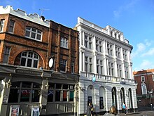
 A view of Sutton High Street within its Conservation Area section | |
| Length | 0.9 mi (1.4 km)[1] |
|---|---|
| Postal code | SM1 |
| Coordinates | 51°21′56″N 0°11′39″W / 51.36552°N 0.194094°W |
| north end | Angel Hill 51°22′18″N 0°11′40″W / 51.3718°N 0.1945°W |
| south end | Brighton Road 51°21′33″N 0°11′29″W / 51.3593°N 0.1913°W |
Sutton High Street is a high street[2] running north–south through the town of Sutton in the London Borough of Sutton.
The High Street area constitutes the sixth most important retail centre in London, and is home to many restaurants and major retail names. It is pedestrianised for most of its length, and a conservation area runs down a three hundred yard section. There are three examples of public art in the street, and parks at either end of it. In 2017 the High Street gained Heritage Action Zone status, the first in London to do so.
- ^ "Walking directions to High St/B2230". Google Maps. Google Maps. Retrieved 27 April 2014.
- ^ "Filmmaking renaissance for borough of Sutton". BBC. Retrieved 2 December 2013.
