Back Swansea (Massachusetts) Catalan Свонси (Массачусетс) CE Swansea (lungsod sa Tinipong Bansa, Massachusetts) CEB Swansea, Massachusetts CY Swansea (Massachusetts) Spanish Swansea (Massachusetts) EU سوانسی، ماساچوست FA Swansea (Massachusetts) French Swansea, Massachusetts HT Swansea (Massachusetts) Italian
Swansea, Massachusetts | |
|---|---|
 Swansea Town Hall | |
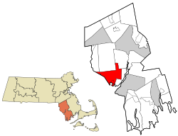
 Location in Bristol County in Massachusetts | |
| Coordinates: 41°44′53″N 71°11′25″W / 41.74806°N 71.19028°W | |
| Country | United States |
| State | Massachusetts |
| County | Bristol |
| Settled | 1662 |
| Incorporated | March 5, 1667 |
| Government | |
| • Type | Open town meeting |
| Area | |
• Total | 25.5 sq mi (66.1 km2) |
| • Land | 23.1 sq mi (59.7 km2) |
| • Water | 2.5 sq mi (6.4 km2) |
| Elevation | 22 ft (7 m) |
| Population (2020) | |
• Total | 17,144 |
| • Density | 670/sq mi (260/km2) |
| Time zone | UTC-5 (Eastern) |
| • Summer (DST) | UTC-4 (Eastern) |
| ZIP code | 02777 |
| Area code | 508 / 774 |
| FIPS code | 25-68750 |
| GNIS feature ID | 0619439 |
| Website | www.swanseama.gov |
Swansea is a town in Bristol County in southeastern Massachusetts, United States. It is located at the mouth of the Taunton River, just west of Fall River, 47 miles (76 km) south of Boston, and 12 miles (19 km) southeast of Providence, Rhode Island. The population was 17,144 at the 2020 census.[1] The villages of Hortonville, Barneyville and Ocean Grove are located in the town.
Swansea is a part of the South Coast region of Massachusetts which encompasses the cities and towns that surround Buzzards Bay (excluding the Elizabeth Islands, Bourne and Falmouth), Mount Hope Bay and the Sakonnet River.
- ^ "Census - Geography Profile: Swansea town, Massachusetts". United States Census Bureau. Retrieved November 11, 2021.

