Back تيرني (نارا) Arabic تنری، نارا AZB Tenri Catalan Тэнри CE Tenri (lungsod sa Hapon) CEB Tenri German Tenri EO Tenri (Nara) Spanish Tenri (Nara) EU تنری، نارا FA
Tenri
天理市 | |
|---|---|
 Top left: View of Headquarter in Tenri religious community, Top right: Tenri religious school, Middle left: View of a point of side of mount Miwa road, Middle right: Stone site in Ryuo Mount Castle, Bottom: Tenri Reference Museum | |
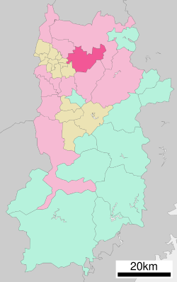
 Location of Tenri in Nara Prefecture | |
 | |
| Coordinates: 34°35′48″N 135°50′14″E / 34.59667°N 135.83722°E | |
| Country | Japan |
| Region | Kansai |
| Prefecture | Nara |
| Government | |
| • Mayor | Keisaku Minami |
| Area | |
• Total | 86.42 km2 (33.37 sq mi) |
| Population (September 30, 2024) | |
• Total | 60,890 |
| • Density | 700/km2 (1,800/sq mi) |
| Time zone | UTC+09:00 (JST) |
| City hall address | 605 Kawaharajō-chō, Tenri-shi, Nara-ken |
| Website | Official website |
| Symbols | |
| Flower | Ume |
| Tree | Ginkgo |

Tenri (天理市, Tenri-shi) is a city located in Nara Prefecture, Japan. As of 30 September 2024[update], the city had an estimated population of 60,890 in 29456 households, and a population density of 700 persons per km2.[1] The total area of the city is 86.42 km2 (33.37 sq mi).[2] The city is named after the Japanese new religion Tenrikyo, which has its headquarters in the city.
- ^ "Tenri City official statistics" (in Japanese). Japan.
- ^ "第1章 天理市の概要" (PDF) (in Japanese). Japan: Tenri City. Retrieved 23 October 2024.


