River in England
| The Moss |
|---|
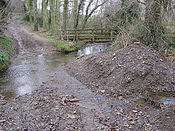
 The Moss, just to the north of Troway. |
 |
|
| Country | England |
|---|
|
|
| Source | |
|---|
| • location | Coalpit Wood, Coal Aston, Derbyshire |
|---|
| • elevation | 518 feet (158 m) |
|---|
|
|
| Mouth | |
|---|
• location | River Rother at Eckington |
|---|
| Length | 4.8 miles (7.7 km) |
|---|
|
|
|
|
|
|
|
|
|
source near Jordanthorpe
|
|
|
|
|
|
|
|
|
|
|
|
Owler Car Brook
|
|
|
|
|
|
tributary (from Lightwood)
|
|
|
|
|
|
Sickle Brook
|
|
|
|
|
|
Site of Foxholes Wheel
|
|
|
|
|
|
tributary (from Charnock Hall)
|
|
|
|
|
|
Troway Brook
|
|
|
|
|
|
tributary (from Dobholme Wood)
|
|
|
|
|
|
Mill Pond
|
|
|
|
|
|
Site of Skelper Wheel
|
|
|
|
|
|
Scythe Manufactory mill pond
|
|
|
|
|
|
|
|
|
|
|
|
Birleyhay Bridge
|
|
|
|
|
|
Robin Brook
|
|
|
|
|
|
Ford Lane Bridges, Ford
|
|
|
|
|
|
|
|
|
|
|
|
Site of Ford Wheel
|
|
|
|
|
|
Site of Sough Wheel
|
|
|
|
|
|
Ridgeway Brook
|
|
|
|
|
|
|
|
|
|
|
|
Never Fear dam and wheel
|
|
|
|
|
|
tributary (from Plumbley)
|
|
|
|
|
|
Site of Fields Wheel
|
|
|
|
|
|
tributary (from Plumbley)
|
|
|
|
|
|
Footrail Dam
|
|
|
|
|
|
Site of Lower Carlton Wheel
|
|
|
|
|
|
Footbridge near Plumbley Colliery
|
|
|
|
|
|
Site of Park Mill (flour)
|
|
|
|
|
|
Gashouse Lane Bridge
|
|
|
|
|
|
Weir
|
|
|
|
|
|
A6135 Sheffield Road Bridge
|
|
|
|
|
|
site of saw mill
|
|
|
|
|
|
B6053 Rotherham Road Bridge
|
|
|
|
|
|
Weir for supply to RVCP
|
|
|
|
|
|
River Rother
|
|
|
|
|
|
|
|
|
|
|
|
|
|
|
|
The Moss is a brook in North East Derbyshire, England.
When Rother Valley Country Park was built in the 1980s, constructors used water from The Moss to fill the lakes.[1]


